
ファイル:Ain al-Assad air base, 8 jan 2020.png

このプレビューのサイズ: 800 × 453 ピクセル。 その他の解像度: 320 × 181 ピクセル | 640 × 362 ピクセル | 1,024 × 580 ピクセル | 1,280 × 724 ピクセル | 2,000 × 1,132 ピクセル。
元のファイル (2,000 × 1,132 ピクセル、ファイルサイズ: 4.5メガバイト、MIME タイプ: image/png)
ウィキメディア・コモンズのファイルページにある説明を、以下に表示します。
|
概要
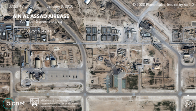
| 解説 | Satellite image, showing the damage to at least five structures at Ain al-Assad air base in Iraq in a series of precision missile strikes launched by Iran |
| 日付 | |
| 原典 |
First upload: Brumfiel, Geoff; Welna, David (8 January 2020). Satellite Photos Reveal Extent Of Damage From Iranian Strike On Air Base In Iraq. NPR. Current upload: Garger, Kenneth (8 January 2020). Before-and-after satellite images show damage to Iraqi base hit by Iran. New York Post. |
| 作者 | Planet Labs, Inc. / Middlebury Institute of International Studies at Monterey |
| 許可 (ファイルの再利用) |
There is a copyright notice in the upper right of this image. "© 2020 Planet Labs, Inc. cc-by-sa 4.0" |
ライセンス
このファイルはクリエイティブ・コモンズ 表示-継承 4.0 国際ライセンスのもとに利用を許諾されています。
帰属: Planet Labs, Inc.
- あなたは以下の条件に従う場合に限り、自由に
- 共有 – 本作品を複製、頒布、展示、実演できます。
- 再構成 – 二次的著作物を作成できます。
- あなたの従うべき条件は以下の通りです。
- 表示 – あなたは適切なクレジットを表示し、ライセンスへのリンクを提供し、変更があったらその旨を示さなければなりません。これらは合理的であればどのような方法で行っても構いませんが、許諾者があなたやあなたの利用行為を支持していると示唆するような方法は除きます。
- 継承 – もしあなたがこの作品をリミックスしたり、改変したり、加工した場合には、あなたはあなたの貢献部分を元の作品とこれと同一または互換性があるライセンスの下に頒布しなければなりません。
ファイルの履歴
過去の版のファイルを表示するには、その版の日時をクリックしてください。
| 日付と時刻 | サムネイル | 寸法 | 利用者 | コメント | |
|---|---|---|---|---|---|
| 現在の版 | 2020年1月9日 (木) 06:14 | | 2,000 × 1,132 (4.5メガバイト) | EnchanterTim | Higher resolution from: https://nypost.com/2020/01/08/before-and-after-satellite-images-show-damage-to-iraqi-base-hit-by-iran/ |
| 2020年1月8日 (水) 19:52 |  | 800 × 449 (805キロバイト) | Cold Season | {{Information |Description= Satellite image, showing the damage to at least five hangars and buildings at Ain al-Assad air base in Iraq in a series of precision missile strikes launched by Iran |Source= [https://www.npr.org/2020/01/08/794517031/satellite-photos-reveal-extent-of-damage-at-al-assad-air-base?t=1578512699906 Satellite Photos Reveal Extent Of Damage From Iranian Strike On Air Base In Iraq]. NPR. |Date= 8 January 2020 |Author= Planet Labs Inc./Middlebury Institute |Permission= |ot... |
ファイルの使用状況
以下のページがこのファイルを使用しています:
グローバルなファイル使用状況
以下に挙げる他のウィキがこの画像を使っています:
- ar.wikipedia.org での使用状況
- be.wikipedia.org での使用状況
- ca.wikipedia.org での使用状況
- ckb.wikipedia.org での使用状況
- en.wikipedia.org での使用状況
- es.wikipedia.org での使用状況
- fa.wikipedia.org での使用状況
- fi.wikipedia.org での使用状況
- fr.wikipedia.org での使用状況
- he.wikipedia.org での使用状況
- id.wikipedia.org での使用状況
- ka.wikipedia.org での使用状況
- ko.wikipedia.org での使用状況
- nl.wikipedia.org での使用状況
- nl.wikinews.org での使用状況
- pnb.wikipedia.org での使用状況
- pt.wikipedia.org での使用状況
- ru.wikipedia.org での使用状況
- ru.wikinews.org での使用状況
- so.wikipedia.org での使用状況
- uk.wikipedia.org での使用状況
- ur.wikipedia.org での使用状況
- vi.wikipedia.org での使用状況
- www.wikidata.org での使用状況
- zh.wikipedia.org での使用状況