
ファイル:Argentine map of Argentina.png

このプレビューのサイズ: 320 × 599 ピクセル。 その他の解像度: 256 × 480 ピクセル | 990 × 1,853 ピクセル。
元のファイル (990 × 1,853 ピクセル、ファイルサイズ: 247キロバイト、MIME タイプ: image/png)
ウィキメディア・コモンズのファイルページにある説明を、以下に表示します。
|
概要
| 解説 |
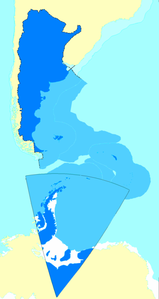
Español: Mapa de la Argentina con todos los territorios reconocidos por su gobierno como propios.
English: Map of Argentina showing all the territories recognized by that country's government as their own.
Français : Carte de l'Argentine incluant tous les territoires reconnus par le gouvernement de ce pays comme étant les leurs. |
| 日付 |
|
| 原典 |
English: Updated following the sovereign waters' change as explained here |
| 作者 | Argentino |
ライセンス
このファイルはクリエイティブ・コモンズ 表示-継承 2.5 一般ライセンスのもとに利用を許諾されています。
帰属: Andrés Baldrich
- あなたは以下の条件に従う場合に限り、自由に
- 共有 – 本作品を複製、頒布、展示、実演できます。
- 再構成 – 二次的著作物を作成できます。
- あなたの従うべき条件は以下の通りです。
- 表示 – あなたは適切なクレジットを表示し、ライセンスへのリンクを提供し、変更があったらその旨を示さなければなりません。これらは合理的であればどのような方法で行っても構いませんが、許諾者があなたやあなたの利用行為を支持していると示唆するような方法は除きます。
- 継承 – もしあなたがこの作品をリミックスしたり、改変したり、加工した場合には、あなたはあなたの貢献部分を元の作品とこれと同一または互換性があるライセンスの下に頒布しなければなりません。
ファイルの履歴
過去の版のファイルを表示するには、その版の日時をクリックしてください。
| 日付と時刻 | サムネイル | 寸法 | 利用者 | コメント | |
|---|---|---|---|---|---|
| 現在の版 | 2009年9月5日 (土) 18:59 | | 990 × 1,853 (247キロバイト) | Argentino | en: Added the changes in the continental shelf the argentinian government sent to the UN SOURCE: the UNITED NATIONS' OFFICIAL PAGE WWW.UN.ORG - READ BEFORE FLAMING http://www.un.org/Depts/los/clcs_new/submissions_files/arg25_09/arg2009e_summary_esp.pdf |
| 2006年8月25日 (金) 21:36 |  | 990 × 1,853 (328キロバイト) | Argentino | Map of Argentina showing all the territories recognized by that country's governmet as their own. Mapa de la Argentina con todos los territorios reconocidos por su gobierno como propios. Created by me following the proportion of distances exactly as fo |
ファイルの使用状況
以下のページがこのファイルを使用しています:
グローバルなファイル使用状況
以下に挙げる他のウィキがこの画像を使っています:
- af.wikipedia.org での使用状況
- ast.wikipedia.org での使用状況
- da.wikipedia.org での使用状況
- de.wikipedia.org での使用状況
- en.wikipedia.org での使用状況
- eo.wikipedia.org での使用状況
- es.wikipedia.org での使用状況
- Antártida Argentina
- Irredentismo
- Espacio marítimo argentino
- Anexo:Puntos extremos de Argentina
- Wikiproyecto Discusión:Argentina/Archivo 2006
- Usuario:ENRIQUE GUARDIA
- Anexo:Países transcontinentales
- Discusión:Mar Argentino
- Usuario Discusión:Nerêo/2009
- Usuario discusión:Eduardomanuel
- Irredentismo argentino
- Usuario:Rosarigasinazo
- Usuario:Cacen Gymraeg/Bar del Atlántico Sur
- es.wikivoyage.org での使用状況
- fr.wikipedia.org での使用状況
- gl.wikipedia.org での使用状況
- id.wikipedia.org での使用状況
- it.wikipedia.org での使用状況
- mk.wikipedia.org での使用状況
- no.wikipedia.org での使用状況
- pl.wikipedia.org での使用状況
- pt.wikipedia.org での使用状況
- rm.wikipedia.org での使用状況
- ru.wikipedia.org での使用状況
- sk.wikipedia.org での使用状況
- uk.wikipedia.org での使用状況
- www.wikidata.org での使用状況