
ファイル:Barentsz arctic map.jpg
高解像度版はありません。
Barentsz_arctic_map.jpg (650 × 517 ピクセル、ファイルサイズ: 102キロバイト、MIME タイプ: image/jpeg)
ウィキメディア・コモンズのファイルページにある説明を、以下に表示します。
|
概要
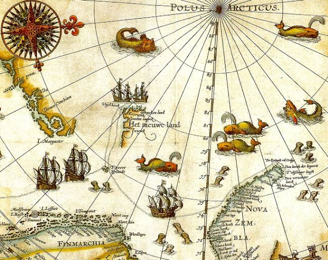
| 解説 | Portion of 1598 map of Arctic exploration by Willem Barentsz. Spitsbergen, here mapped for the first time, is indicated as "Het Nieuwe Land" (Dutch for "the New Land"), center-left. |
| 日付 | 1598, misdated to 1599 for no stated reason but possibly a 2nd edition or reprint |
| 原典 | Northern Lights Route project at the University Library of Tromsø, from an original print based on Barentsz's charts |
| 作者 | Original charts by Willem Barentsz, drawn by Cornelis Claesz, engraved by Baptista van Doetecum |
| 許可 (ファイルの再利用) |
Public domain (over 70 years since creator's death) |
| その他のバージョン |
|
.jpg)


_door_Willem_Barendsz_(titel_op_object),_NG-800.jpg)
ライセンス
|
この著作物は、著作権の保護期間が著作者の死後70年以下である国・地域においてパブリックドメインの状態にあります。
| |
| このファイルは著作権法の既知の制約(隣接権や関連する権利を含む)から自由であると特定されています。 | |
ファイルの履歴
過去の版のファイルを表示するには、その版の日時をクリックしてください。
| 日付と時刻 | サムネイル | 寸法 | 利用者 | コメント | |
|---|---|---|---|---|---|
| 現在の版 | 2006年7月26日 (水) 09:14 | | 650 × 517 (102キロバイト) | TheGrappler | {{Information |Description=Portion of 1599 map of Arctic exploration by Willem Barentsz. Spitsbergen, here mapped for the first time, is indicated as "Het Nieuwe Land" (Dutch for "the New Land"), center-left. |Source=[http://www.ub.uit.no/northernlights/e |
ファイルの使用状況
以下のページがこのファイルを使用しています:
グローバルなファイル使用状況
以下に挙げる他のウィキがこの画像を使っています:
- arz.wikipedia.org での使用状況
- ast.wikipedia.org での使用状況
- ca.wikipedia.org での使用状況
- de.wikipedia.org での使用状況
- el.wikipedia.org での使用状況
- en.wikipedia.org での使用状況
- es.wikipedia.org での使用状況
- fa.wikipedia.org での使用状況
- fr.wikipedia.org での使用状況
- id.wikipedia.org での使用状況
- it.wikipedia.org での使用状況
- la.wikipedia.org での使用状況
- no.wikipedia.org での使用状況
- ru.wikipedia.org での使用状況
- uk.wikipedia.org での使用状況