
ファイル:Carte des barrières de séparation.svg

この SVG ファイルのこの PNG プレビューのサイズ: 800 × 410 ピクセル. その他の解像度: 320 × 164 ピクセル | 640 × 328 ピクセル | 1,024 × 525 ピクセル | 1,280 × 656 ピクセル | 2,560 × 1,313 ピクセル | 1,726 × 885 ピクセル。
元のファイル (SVG ファイル、1,726 × 885 ピクセル、ファイルサイズ: 1.38メガバイト)
ウィキメディア・コモンズのファイルページにある説明を、以下に表示します。
|
概要
| 解説 |
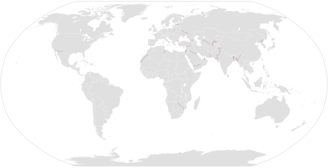
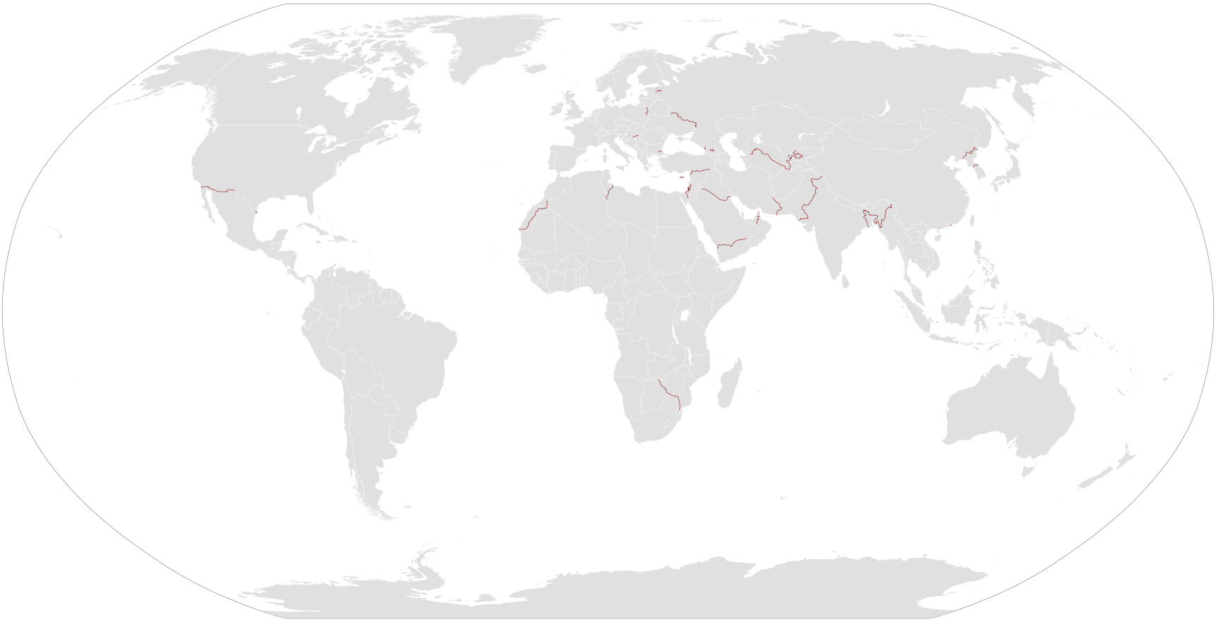
English: Map of separation barriers in the world. The exact status of many barriers is unknown (length completed, etc), but also the number of barriers. A separation barrier is not necessarily a border barrier
Français : Carte des barrières de séparation dans le monde. L'état exacte de plusieurs barrières est inconnue (proportion terminée, etc), mais aussi le nombre de barrières. |
| 日付 | |
| 原典 |
Multiple:
|
| 作者 | 投稿者自身による著作物 |
ライセンス
| この著作物の著作権者である私は、この著作物における権利を放棄しパブリックドメインとします。これは全世界で適用されます。 一部の国では、これが法的に可能ではない場合があります。その場合は、次のように宣言します。 私は、あらゆる人に対して、法により必要とされている条件を除き、如何なる条件も課すことなく、あらゆる目的のためにこの著作物を使用する権利を与えます。 |
ファイルの履歴
過去の版のファイルを表示するには、その版の日時をクリックしてください。
| 日付と時刻 | サムネイル | 寸法 | 利用者 | コメント | |
|---|---|---|---|---|---|
| 現在の版 | 2020年8月3日 (月) 21:47 | | 1,726 × 885 (1.38メガバイト) | TheNavigatrr | Updated Estonia border with new completion date, per https://news.err.ee/974691/opinion-state-hinting-it-s-time-to-cut-corners-on-estonia-s-eastern-border Also made the pixel size larger so it can be seen and zoomed in. |
| 2019年7月22日 (月) 20:59 |  | 863 × 443 (1.39メガバイト) | TheNavigatrr | Corrected border barrier progress at the southeast part of the West Bank and the Israeli border with Lebanon, as well as correcting the shape of the Turkey-Syria barrier. | |
| 2016年1月28日 (木) 13:25 |  | 863 × 443 (1.39メガバイト) | Mapeh | Ajout Bulgarie-Turquie & Hongrie-Croatie | |
| 2015年9月6日 (日) 16:57 |  | 863 × 443 (1.27メガバイト) | Mapeh | Ajout de quelques barrières | |
| 2014年1月10日 (金) 11:30 |  | 863 × 443 (1.38メガバイト) | Mapeh | ajout de quelques barrières de plus | |
| 2013年4月13日 (土) 20:11 |  | 863 × 443 (1.37メガバイト) | Mapeh | {{Information |Description ={{en|1=Map of en:separation barriers in the world.}} {{fr|1=Carte des fr:barrières de séparation dans le monde.}} |Source =Multiple |Author ={{self}} |Date =2013-04-13 |Permission ... |
ファイルの使用状況
以下のページがこのファイルを使用しています:
グローバルなファイル使用状況
以下に挙げる他のウィキがこの画像を使っています:
- ar.wikipedia.org での使用状況
- bg.wikipedia.org での使用状況
- de.wikipedia.org での使用状況
- en.wikipedia.org での使用状況
- fr.wikipedia.org での使用状況
- he.wikipedia.org での使用状況
- ht.wikipedia.org での使用状況
- it.wikipedia.org での使用状況
- ko.wikipedia.org での使用状況
- nl.wikipedia.org での使用状況
- pl.wikipedia.org での使用状況
- ru.wikipedia.org での使用状況
- uk.wikipedia.org での使用状況
- zh.wikipedia.org での使用状況