
ファイル:China Hong Kong 4 levels localisation.svg

この SVG ファイルのこの PNG プレビューのサイズ: 705 × 599 ピクセル. その他の解像度: 282 × 240 ピクセル | 565 × 480 ピクセル | 904 × 768 ピクセル | 1,205 × 1,024 ピクセル | 2,409 × 2,048 ピクセル | 1,000 × 850 ピクセル。
元のファイル (SVG ファイル、1,000 × 850 ピクセル、ファイルサイズ: 703キロバイト)
ウィキメディア・コモンズのファイルページにある説明を、以下に表示します。
|
| 解説 |
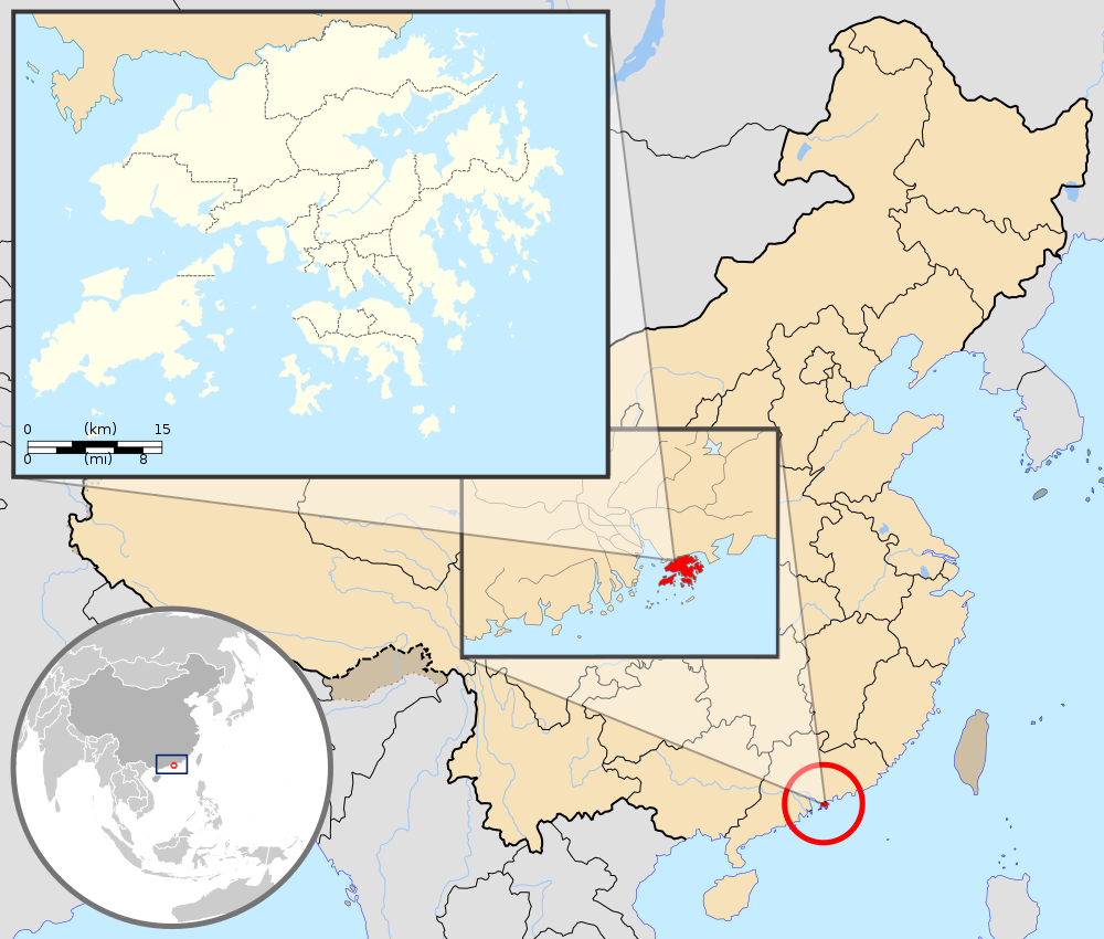
English: Map showing Hong Kong's location in Asia, on China's south coast, and Hong Kong's 18 districts
Français : Carte de Hong Kong : situation en Asie, situation sur le littoral chinois, carte des 18 districts
中文(繁體):顯示香港在亞洲,中國南海岸和香港18區的位置的地圖 |
| 日付 | (UTC) |
| 原典 | |
| 作者 |
|
| その他のバージョン | このファイルの派生的著作物: Hebao island map.jpg |
この画像には画像編集が施されています。原本に対して次のデジタル的な変更が行われました。
|
このファイルはクリエイティブ・コモンズ 表示-継承 3.0 非移植ライセンスのもとに利用を許諾されています。
帰属: GFDL
- あなたは以下の条件に従う場合に限り、自由に
- 共有 – 本作品を複製、頒布、展示、実演できます。
- 再構成 – 二次的著作物を作成できます。
- あなたの従うべき条件は以下の通りです。
- 表示 – あなたは適切なクレジットを表示し、ライセンスへのリンクを提供し、変更があったらその旨を示さなければなりません。これらは合理的であればどのような方法で行っても構いませんが、許諾者があなたやあなたの利用行為を支持していると示唆するような方法は除きます。
- 継承 – もしあなたがこの作品をリミックスしたり、改変したり、加工した場合には、あなたはあなたの貢献部分を元の作品とこれと同一または互換性があるライセンスの下に頒布しなければなりません。
元のアップロードログ
This image is a derivative work of the following images:
- File:Hong_Kong_Location.svg licensed with PD-self
- 2008-08-27T13:27:11Z Joowwww 1270x640 (234741 Bytes) a few minor tweaks
- 2008-08-27T13:18:03Z Joowwww 1270x640 (234389 Bytes) new version: more detailed, colours are standard with most other locator maps
- 2008-04-20T13:54:51Z Joowwww 1270x640 (79729 Bytes) reduced height, removed map border and added rivers and hk's maritime border
- 2008-04-09T11:31:22Z Joowwww 1270x977 (66085 Bytes) {{Information |Description=A map showing Hong Kong's location in Asia, in China and on China's south coast. |Source=self-made |Date=2008-04-09 |Author= [[User:Joowwww|Joowwww]] |Permission={{PD-self}} |other_versions= }} {{Cr
- File:Map_of_Hong_Kong_18Districts_ZH.svg licensed with Cc-by-sa-3.0, GFDL
- 2008-07-05T21:14:26Z Moddlyg 1454x1083 (381097 Bytes) == Summary == {{Information |Description={{en|1=Map of Hong Kong & 18 Districts (Chinese Version)}} |Source=Own work by uploader |Author={{User:Moddlyg/Sign}} |Date=2008/7/6 |Permission= |other_versions= }} {{ImageUpload|ful
- 2008-07-05T20:59:35Z Moddlyg 1454x1083 (262750 Bytes) {{Information |Description={{en|1=Map of Hong Kong & 18 Districts (Chinese Version)}} |Source=Own work by uploader |Author=~~~ |Date=2008/7/6 |Permission= |other_versions= }}
- File:China_Hong_Kong.svg licensed with PD-self
- 2008-08-13T16:22:08Z Joowwww 1000x850 (212124 Bytes) added missing laos/vietnam border
- 2008-05-14T11:14:46Z Joowwww 1000x850 (210515 Bytes) {{Information |Description=An SVG map of China with Hong Kong special administrative region highlighted and circled Legend:[[Image:China map legend.png]] |Source=self-made; based on CIA public domain maps: *http://www.lib.ut
Uploaded with derivativeFX
ファイルの履歴
過去の版のファイルを表示するには、その版の日時をクリックしてください。
| 日付と時刻 | サムネイル | 寸法 | 利用者 | コメント | |
|---|---|---|---|---|---|
| 現在の版 | 2019年9月22日 (日) 21:33 | | 1,000 × 850 (703キロバイト) | En rouge | added map scale, for the higher resolution sub-picture |
| 2015年5月14日 (木) 07:57 |  | 1,000 × 850 (686キロバイト) | Flappiefh | Fixed colour of Haïnan. | |
| 2010年3月5日 (金) 18:40 |  | 1,000 × 850 (685キロバイト) | Pethrus | {{Information |Description={{en|1=Map showing Hong Kong's location in Asia, on China's south coast, and Hong Kong's 18 disctricts}} {{fr|1=Carte de Hong Kong : situation en Asie, situation sur le littoral chinois, carte des 18 disctricts}} |Source=*[[:Fil |
ファイルの使用状況
以下のページがこのファイルを使用しています:
グローバルなファイル使用状況
以下に挙げる他のウィキがこの画像を使っています:
- ami.wikipedia.org での使用状況
- as.wikipedia.org での使用状況
- azb.wikipedia.org での使用状況
- bh.wikipedia.org での使用状況
- bo.wikipedia.org での使用状況
- br.wikipedia.org での使用状況
- cbk-zam.wikipedia.org での使用状況
- dty.wikipedia.org での使用状況
- dz.wikipedia.org での使用状況
- en.wikipedia.org での使用状況
- fi.wikipedia.org での使用状況
- fr.wikipedia.org での使用状況
- fr.wikinews.org での使用状況
- fr.wiktionary.org での使用状況
- fur.wikipedia.org での使用状況
- gcr.wikipedia.org での使用状況
- gn.wikipedia.org での使用状況
- incubator.wikimedia.org での使用状況
- io.wikipedia.org での使用状況
- it.wikipedia.org での使用状況
- li.wikipedia.org での使用状況
- lld.wikipedia.org での使用状況
- lo.wikipedia.org での使用状況
- mad.wikipedia.org での使用状況
- mai.wikipedia.org での使用状況
このファイルのグローバル使用状況を表示する。