
ファイル:Earnest Will map.png
このプレビューのサイズ: 748 × 600 ピクセル。 その他の解像度: 300 × 240 ピクセル | 599 × 480 ピクセル | 887 × 711 ピクセル。
元のファイル (887 × 711 ピクセル、ファイルサイズ: 81キロバイト、MIME タイプ: image/png)
ウィキメディア・コモンズのファイルページにある説明を、以下に表示します。
|
概要
| 解説 |
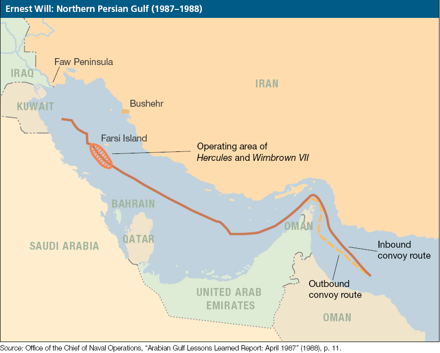
English: Map shows routes of in- and outbound convoys under protection of warships of the US Navy while the tanker war (dubbed Operation Earnest Will) |
| 日付 | |
| 原典 | Via https://apps.dtic.mil/sti/pdfs/ADA403506.pdf, where it is cited to Office of Chief of Naval Operations, "Arabian Gulf Lessons Learned Report: April 1987 (1988), p. 11. |
| 作者 | Office of Chief of Naval Operations |
ライセンス
このファイルは、アメリカ合衆国の連邦政府と雇用関係にある公務員がその職務上作成したアメリカ合衆国政府の著作物であり、アメリカ合衆国の著作権法上パブリックドメインに属します (17 U.S.C. §105)。
注意:このライセンスは、アメリカ合衆国政府の著作物についてのみ効力を有します。アメリカ合衆国の各州、郡、その他の地方自治体が作成した著作物に対しては適用できません。
|
 | |
| このファイルは著作権法の既知の制約(隣接権や関連する権利を含む)から自由であると特定されています。 | ||
ファイルの履歴
過去の版のファイルを表示するには、その版の日時をクリックしてください。
| 日付と時刻 | サムネイル | 寸法 | 利用者 | コメント | |
|---|---|---|---|---|---|
| 現在の版 | 2006年5月1日 (月) 12:34 | | 887 × 711 (81キロバイト) | Schlendrian | Source: http://www.dtic.mil/doctrine/jel/jfq_pubs/0629.pdf There contributed to ''Office of Chief of Naval Operations, "Arabian Gulf lessons learend Report: April 1987 (1988), p. 11.'' map shows routes of in- and outbound convoys under protection of wars |
ファイルの使用状況
以下のページがこのファイルを使用しています:
グローバルなファイル使用状況
以下に挙げる他のウィキがこの画像を使っています:
- ar.wikipedia.org での使用状況
- ast.wikipedia.org での使用状況
- azb.wikipedia.org での使用状況
- az.wikipedia.org での使用状況
- ca.wikipedia.org での使用状況
- ckb.wikipedia.org での使用状況
- cs.wikipedia.org での使用状況
- de.wikipedia.org での使用状況
- en.wikipedia.org での使用状況
- es.wikipedia.org での使用状況
- fa.wikipedia.org での使用状況
- fi.wikipedia.org での使用状況
- fr.wikipedia.org での使用状況
- id.wikipedia.org での使用状況
- it.wikipedia.org での使用状況
- mzn.wikipedia.org での使用状況
- ru.wikipedia.org での使用状況
- tg.wikipedia.org での使用状況
- uk.wikipedia.org での使用状況
- www.wikidata.org での使用状況