
ファイル:Hooker Map of the State of Coahuila and Texas 1833 UTA.jpg
元のファイル (3,516 × 2,793 ピクセル、ファイルサイズ: 9.26メガバイト、MIME タイプ: image/jpeg)
ウィキメディア・コモンズのファイルページにある説明を、以下に表示します。
|
概要
| 題名 |
English: Map of the State of Coahuila and Texas |
||||||||||||||||||||||||||
| 記述 |
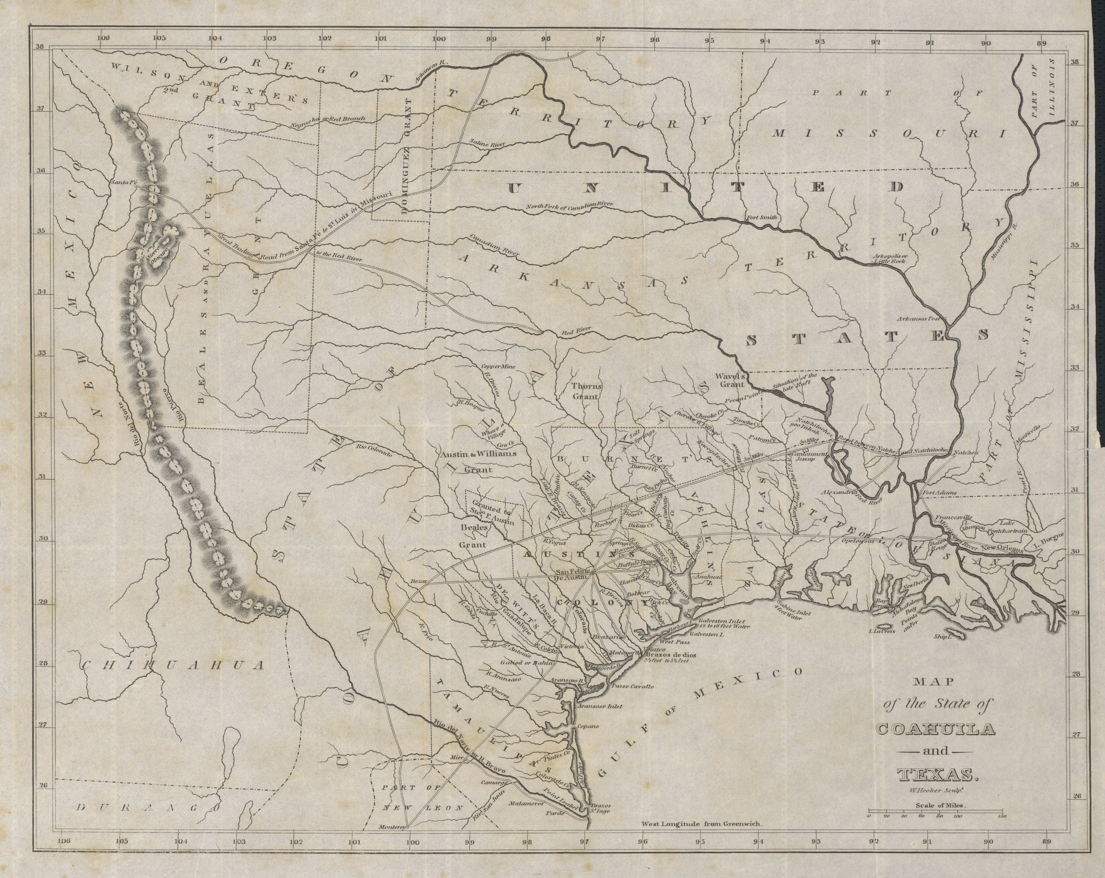
English: Philadelphia engraver, printer, map publisher, and instrument maker William Hooker's Map of Coahuila and Texas first appeared in an 1833 promotional book on Texas by Mary Austin Holley (1784-1846), a first cousin of the famous Texas colonizer Stephen F. Austin. Holley and her publisher, Armstrong & Plaskitt of Baltimore substituted Hooker's map when Henry S. Tanner, the publisher of Stephen F. Austin's large map of Texas, refused to allow the latter to be used in the book. Hooker's map shows the Austin Colony capital town of San Felipe de Austin at the center of roads leading to a number of settlements including Bexar (San Antonio de Bexar), Victoria and Goliad or Bahia, Matagorda, Brazaria (sic, Brazoria), Harrisburg and Buffalo Bayou as well as a road connecting to the older Camino Real or old Spanish road between Bexar and Nacogdoches. Lands granted to individuals under the Mexican empresario system are shown. In addition to Stephen F. Austin's grants awarded in 1821 (confirmed in 1823 and extended by further contracts in 1825, 1827, and 1828), these include the grants of Green DeWitt (contract awarded in 1825), Frost Thorn (1825), Benjamin R. Milam (1826), David G. Burnet (1826), Arthur G. Wavell (1826), Joseph Vehlein (1826 and 1828), Lorenzo de Zavala (1829), Juan Dominguez y Valdez (1829), Richard Exter (1826, 1828), John Charles Beale (1830). The lands in west Texas granted to Beale and José Manuel Royuela and to Austin and his partner Samuel May Williams in 1832 are the latest to appear on the map. References to other land grants are missing but some would appear on later editions in 1834 and 1836. |
||||||||||||||||||||||||||
| 日付 | |||||||||||||||||||||||||||
| 原典 | UTA Libraries Cartographic Connections: 地図 / テキスト | ||||||||||||||||||||||||||
| 作者 |
|
||||||||||||||||||||||||||
| 受入/取得方法 |
English: The University of Texas at Arlington Libraries Special Collections, Gift of Jenkins Garrett |
||||||||||||||||||||||||||
| Geotemporal data | |||||||||||||||||||||||||||
| Map location |
メキシコ テキサス州 |
||||||||||||||||||||||||||
| Georeferencing | If inappropriate please set warp_status = skip to hide. | ||||||||||||||||||||||||||
| Bibliographic data | |||||||||||||||||||||||||||
| 出版物 |
Texas. Observations, Historical, Geographical and Descriptive, in a Series of Letters Written during a Visit to Austin's Colony, with a view to a permanent settlement in that country, in the Autumn of 1831 |
||||||||||||||||||||||||||
| 作者 |
|
||||||||||||||||||||||||||
| 出版地 | ボルティモア | ||||||||||||||||||||||||||
| 出版者 |
Armstrong & Plaskitt |
||||||||||||||||||||||||||
| Archival data | |||||||||||||||||||||||||||
| コレクション |
|
||||||||||||||||||||||||||
| 寸法 | 高さ: 27 cm;幅: 34 cm | ||||||||||||||||||||||||||
| 技法 | エングレービング / 紙 | ||||||||||||||||||||||||||
| artwork-references |
Huseman, Ben W. (2014年) The Price of Manifest Destiny: Maps Relating to the Southwest Borderlands, 1800-1866、アーリントン: The University of Texas at Arlington Libraries、p. 16 Streeter, Thomas W. (1983年) Bibliography of Texas 1795-1845 (第2 ed.)、Woodbridge: Research Publications, Inc.、pp. 376–377, 383, 397 "Revised and Enlarged by Archibald Hanna with a Guide to the Microfilm Collection. First published by Oxford University Press, 1955." Davis, Marty, et al (2007年) Going to Texas: Five Centuries of Texas Maps、フォート・ワース: Texas Christian University Press、17 番、p. 35 Day, James M. (1964年) Maps of Texas 1527-1900、オースティン: The Pemberton Press、pp. 18, 22 |
||||||||||||||||||||||||||
ライセンス

|
This file was provided to Wikimedia Commons by the University of Texas at Arlington Libraries as part of a cooperation project. The University of Texas at Arlington Libraries is part of the University of Texas at Arlington, a public research university located in Arlington, Texas.
|
|
著作者が1846年に死亡しているため、この著作物は、著作権の保護期間が著作者の死後100年以下である国・地域においてパブリックドメインの状態にあります。 この著作物は1929年1月1日以前に公表され、又はアメリカ合衆国著作権局に登録されたため、アメリカ合衆国においてパブリックドメインの状態にあります。 | |
| このファイルは著作権法の既知の制約(隣接権や関連する権利を含む)から自由であると特定されています。 | |
ファイルの履歴
過去の版のファイルを表示するには、その版の日時をクリックしてください。
| 日付と時刻 | サムネイル | 寸法 | 利用者 | コメント | |
|---|---|---|---|---|---|
| 現在の版 | 2019年7月23日 (火) 19:37 | | 3,516 × 2,793 (9.26メガバイト) | Michael Barera | == {{int:filedesc}} == {{Map |title = ''Map of the State of Coahuila and Texas'' |description = {{en|Philadelphia engraver, printer, map publisher, and instrument maker William Hooker's Map of Coahuila and Texas first appeared in an 1833 promotional book on Texas by Mary Austin Holley (1784-1846), a first cousin of the famous Texas colonizer Stephen F. Austin. Holley and her publisher, Armstrong & Plaskitt of Baltimore substituted Hooker's map when Henry S. Tanner, the pub... |
ファイルの使用状況
以下のページがこのファイルを使用しています:
グローバルなファイル使用状況
以下に挙げる他のウィキがこの画像を使っています:
- ca.wikipedia.org での使用状況
- cs.wikipedia.org での使用状況
- el.wikipedia.org での使用状況
- en.wikipedia.org での使用状況
- es.wikipedia.org での使用状況
- ro.wikipedia.org での使用状況
- sv.wikipedia.org での使用状況