
ファイル:Langs N.Amer.png
元のファイル (1,290 × 1,170 ピクセル、ファイルサイズ: 599キロバイト、MIME タイプ: image/png)
ウィキメディア・コモンズのファイルページにある説明を、以下に表示します。
|
概要

|
このファイルのベクター画像 (SVG) が利用できます。 使う目的に対し、元画像よりもSVGがより優れている場合、SVG画像を使用して下さい。
File:Langs N.Amer.png → File:Langs N.Amer.svg
|
 |
|
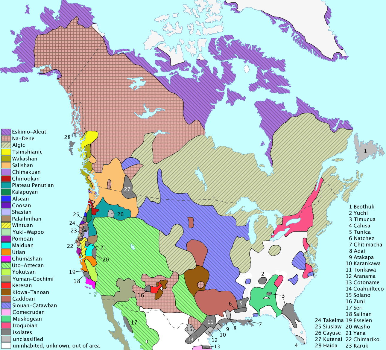
Distribution of North American language families north of Mexico
- Deutsch (German): Image:Langs_N.Amer_Deutsch.png
- español (Spanish): Image:Langs N.Amer espanol.png
- français (French): Image:Langs N.Amer fr.png
Info
- created by en:User:ish ishwar in 2005, using the GIMP software
- released under CC-by-2.0
About sources
Map redrawn and modified primary based on two maps by cartographer Roberta Bloom appearing in Mithun (1999:xviii–xxi). Incidentally, these maps are very derivative of the Driver map of the 1950s–60s (which means that, although published in 1999, it is not as up-to-date as one might think). The other main source used is the up-to-date and very well-done map found in Goddard (1996), which was revised as Goddard (1999). Essentially, Bloom's map was used for the projection and general outline of language borders while Goddard's maps were used to adjust Bloom's borders to reflect the more recent research.
Additional references include Sturtevant (since 1978), Mithun (1999:606–16), and Campbell (1997:353–76). Mithun and Campbell have several maps based on the maps found in Sturtevant (since 1978) and Bright (1992).
Mithun, M. (2001年) The Languages of Native North America、Cambridge Language Surveys、Cambridge University Press ISBN: 978-0-521-29875-9.
About map content
- Map delineates each language family in a unique color.
- Language isolates are all in dark grey, e.g. Chitimacha (#7) is an isolate in Louisiana. This is not meant to imply any relationship among them whatsoever. All isolates are assigned a number and listed on the right side of map.
- Unclassified languages (i.e. #1 Beothuk, #4 Calusa, #8 Adai, #10 Karankawa, #12 Aranama, #15 Solano, #19 Esselen, #26 Cayuse) are in light grey and are also assigned a number and listed with the isolates on the right. (Unclassified languages in the case of North America are unclassified because there is not sufficient data to determine genealogical relationship.)
- Areas in white are either
- uninhabited (in Alaska, Canada, Greenland),
- unknown (due to early extinction and little or no data; this is mostly in the East), or
- outside of subject area (in Mexico). (note that Seri (#17) is included because it is usually considered part of the Southwest culture area and also included in various Hokan phylum proposals.)
- This is a historical map: Although most languages are still spoken in North America, the extent of their distribution has been profoundly affected by European contact — many languages have become extinct (sometimes including even the peoples). (See Endangered language.)
- Language areas are those at earliest time of European contact, as far as can be determined. Since contact occurred at different times in different areas, no historical Native American maps of the entire continent are of a single time period.
- Language areas are not as well-defined as this map would suggest: borders are often fuzzy and arbitrary and the entire language area may not be fully occupied by language speakers.
- Na-Dene here is Athabaskan-Eyak-Tlingit, excluding Haida (#28).
- The following groupings are disputed by some (or are considered not fully demonstrated):
- Plateau Penutian (aka Shahapwailutan) = Klamath-Modoc (isolate) + Molala (isolate) + Sahaptian (family). Sometimes Cayuse (#26) is included in Plateau Penutian, but this language is not very well documented and is now extinct. Thus, it is considered unclassified here.
- Yuki-Wappo = Yuki (isolate) + Wappo (isolate).
To do
- translation into Spanish & other languages
- extend Mexico coverage (for Comecrudo)?
Links
You might want to compare this map with these two older (1967) maps of only the USA:
There is also an Inuktitut dialect map in Wikipedia:
Be sure to check out the beautiful work of Mutur Zikin (www.muturzikin.com):
- Distribution Linguistique Aux Étas-Unis Et Canada (in English, Basque, French, Spanish)
- Distribution Linguistique En Amérique Latine (in English, Basque, French, Spanish)
Looking for more maps of South America? Go here:
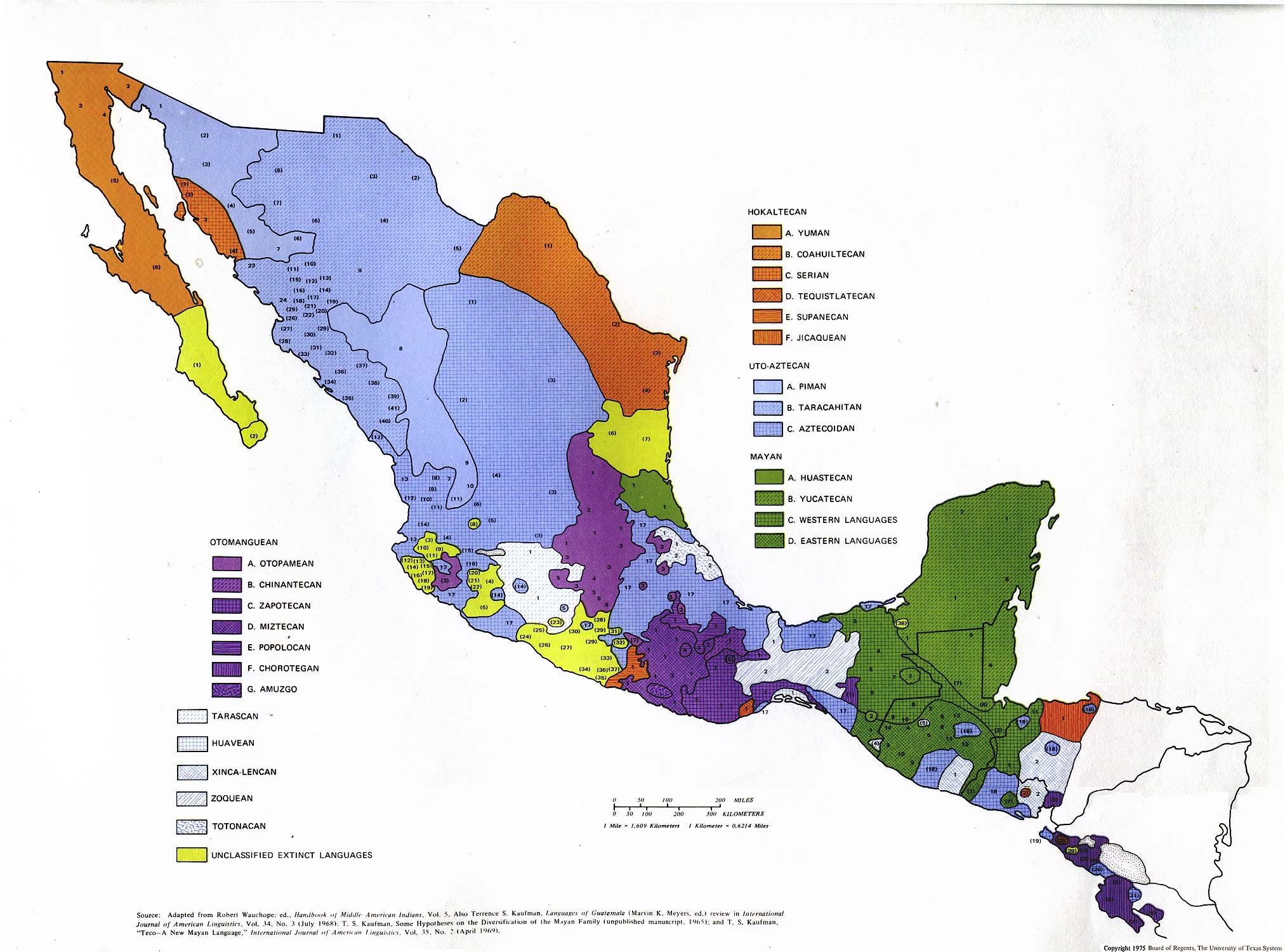
A (older) map of Mexico (provided by the University of Texas):
- Map itself: www.lib.utexas.edu/../aboriginal_map.jpg (in English)
- Text accompanying map: www.lib.utexas.edu/../aboriginal_languages_txt.jpg (in English)
Some pages in Wikipedia:
- Classification schemes for indigenous languages of the Americas (in English)
- Indigenous languages of the Americas (in English)
- Mesoamerican languages (in English)
- Languages of Peru (in English)
- Category: Indigenous languages of the Americas (in English)
- Indigene amerikanische Sprachen (in German)
- Lenguas amerindias (in Spanish)
- Langues amérindiennes (in French)
Some other sites on American languages (in English):
- The Society for the Study of the Indigenous Languages of the Americas
- The Archive of the Indigenous Languages of Latin America アーカイブされたコピー at the Wayback Machine
- Native Languages of the Americas
You might also be interesting in:
- the Aboriginal Mapping Network (in English)
Other maps in this series
These other maps of single families are generated from the main map above.
- Adai
- Algic - Algisch - algiques
- Alsean - Alsea - alséannes
- Atakapa
- Beothuk - béothuk
- Cayuse
- Chimakuan
- Chimariko
- Chinookan - Chinook
- Chitimacha
- Chumashan - Chumash
- Coahuilteco
- Cotoname
- Eskimo-Aleut - Eskimo-Aleutisch - eskimo-aléoutes
- Esselen
- Haida
- Karankawa
- Karuk - Karok
- Keresan - Keres
- Kiowa-Tanoan
- Kutenai
- Muskogean - Muskogee
- Na-Dene - na-déné
- Natchez
- Salishan - Salish
- Utian - Uti
- Yokutsan - Yokut - yokuts
Bibliography
- Bright, William (Ed.). (1992). International encyclopedia of linguistics (Vols. 1-4). New York: Oxford University Press.
- Campbell, Lyle. (1997). American Indian languages: The historical linguistics of Native America. New York: Oxford University Press. ISBN 0-19-509427-1.
- Driver, Harold E. (1969). Indians of North America (2nd rev. ed.). Chicago: Chicago University Press. (Original work 1961).
- Goddard, Ives. (1996). Native languages and language families of North America [Map]. In I. Goddard (Ed.), Handbook of North American Indians: Languages (Vol. 17). (W. C. Sturtevant, General Ed.) Washington, D. C.: Smithsonian Institution. ISBN 0-1604-8774-9.
- Goddard, Ives. (1999). Native languages and language families of North America (rev. and enlarged ed. with additions and corrections). [Map]. Lincoln, NE: University of Nebraska Press (Smithsonian Institute). (Updated version of the map in Goddard 1996). ISBN 0-8032-9271-6.
- Krauss, Michael. (1982). Native peoples and languages of Alaska (rev. ed.). [Map]. Fairbanks, AK: Alaska Native Language Center. ISBN 0-933769-00-8.
- Mithun, Marianne. (1999). The languages of Native North America. Cambridge: Cambridge University Press. ISBN 0-521-23228-7 (hbk); ISBN 0-521-29875-X.
- Powell, John W. (1891). Indian linguistic families of America north of Mexico. Seventh annual report, Bureau of American Ethnology (pp. 1-142). Washington, D.C.: Government Printing Office. (Reprinted in P. Holder (Ed.), 1966, Introduction to Handbook of American Indian languages by Franz Boas and Indian linguistic families of America, north of Mexico, by J. W. Powell, Lincoln: University of Nebraska).
- Sebeok, Thomas Albert (Ed.). (1973). Current trends in linguistics: Linguistics in North America (Vol. 10, Pts. 1-2). The Hague: Mouton.
- Sturtevant, William C. (Ed.). (1978-present). Handbook of North American Indians (Vols. 1-20). Washington, D. C.: Smithsonian Institution. (Vols. 1-3, 16, 18-20 not yet published).
Thank You
Thanks goes to:
- User:Mark Dingemanse for creating his lingustic maps of Africa which inspired me to create this one
- en:User:Wapcaplet for helpful suggestions concerning form
- User:Vlad2i for kindly providing the Français translation
- de:Benutzer:Napa for kindly providing the Deutsch translation
- en:User:kwamikagami for helpful suggestions concerning classification, content, and form
- en:User:Deglr6328 for helpful suggestions concerning accessibility issues involving viewers with color blindness
ライセンス
- あなたは以下の条件に従う場合に限り、自由に
- 共有 – 本作品を複製、頒布、展示、実演できます。
- 再構成 – 二次的著作物を作成できます。
- あなたの従うべき条件は以下の通りです。
- 表示 – あなたは適切なクレジットを表示し、ライセンスへのリンクを提供し、変更があったらその旨を示さなければなりません。これらは合理的であればどのような方法で行っても構いませんが、許諾者があなたやあなたの利用行為を支持していると示唆するような方法は除きます。
ファイルの履歴
過去の版のファイルを表示するには、その版の日時をクリックしてください。
| 日付と時刻 | サムネイル | 寸法 | 利用者 | コメント | |
|---|---|---|---|---|---|
| 現在の版 | 2019年7月20日 (土) 17:28 | | 1,290 × 1,170 (599キロバイト) | Denniss | Reverted to version as of 21:52, 1 March 2009 (UTC) |
| 2019年7月13日 (土) 16:54 |  | 1,290 × 1,170 (840キロバイト) | Thylacinus cynocephalus | Having colonial borders on an indigenous language map is offensive | |
| 2009年3月1日 (日) 21:52 |  | 1,290 × 1,170 (599キロバイト) | Malus Catulus | optipng, pngout | |
| 2006年12月22日 (金) 14:31 |  | 1,290 × 1,170 (668キロバイト) | Mahahahaneapneap | pngcrushed | |
| 2006年11月11日 (土) 00:43 |  | 1,290 × 1,170 (916キロバイト) | Ish ishwar | update | |
| 2006年4月1日 (土) 04:55 |  | 1,296 × 1,176 (678キロバイト) | Locke Cole | smaller file (pngout /f0 Langs_N.Amer.png /b4096) / Change: -315546 bytes ( 68% of original) | |
| 2006年1月7日 (土) 04:01 |  | 1,296 × 1,176 (986キロバイト) | Ish ishwar | adai,chimariko = unclassified; adjust uto-aztec, salinan, southern athabasc., muskogean; + Isla Ángel de la Guarda, Isla del Tiburón, Lake Okeechobee | |
| 2005年12月9日 (金) 21:24 |  | 1,318 × 1,195 (714キロバイト) | Ish ishwar | checker grid pattern to Chumash | |
| 2005年12月6日 (火) 06:12 |  | 1,318 × 1,195 (714キロバイト) | Ish ishwar | forgot seri, fix fam key | |
| 2005年12月6日 (火) 01:21 |  | 1,318 × 1,195 (712キロバイト) | Ish ishwar | update |
ファイルの使用状況
以下のページがこのファイルを使用しています:
グローバルなファイル使用状況
以下に挙げる他のウィキがこの画像を使っています:
- af.wikipedia.org での使用状況
- an.wikipedia.org での使用状況
- ar.wikipedia.org での使用状況
- azb.wikipedia.org での使用状況
- az.wikipedia.org での使用状況
- bat-smg.wikipedia.org での使用状況
- be-tarask.wikipedia.org での使用状況
- beta.wikiversity.org での使用状況
- be.wikipedia.org での使用状況
- bg.wikipedia.org での使用状況
- br.wikipedia.org での使用状況
- ca.wikipedia.org での使用状況
- ca.wikimedia.org での使用状況
- cs.wikipedia.org での使用状況
- cv.wikipedia.org での使用状況
- da.wikipedia.org での使用状況
- da.wikibooks.org での使用状況
- de.wikipedia.org での使用状況
- dsb.wikipedia.org での使用状況
- en.wikipedia.org での使用状況
- History of the Americas
- North America
- Native Americans in the United States
- First Nations in Canada
- Linguistics and the Book of Mormon
- Lower Rio Grande Valley
- User:Ish ishwar
- Classification of the Indigenous languages of the Americas
- Wikipedia:Featured pictures thumbs/03
- Indigenous peoples of the Americas
- Wikipedia:Wikipedia Signpost/2005-12-26/Features and admins
- Wikipedia:Featured picture candidates/December-2005
- Wikipedia:Featured picture candidates/Indigenous language families north of Mexico
- User:Cyde/Featured pictures
- Talk:New World
- Wikipedia:Picture of the day/April 2006
- Wikipedia:POTD/April 1, 2006
- Wikipedia:Picture of the day/April 1, 2006
- Wikipedia:Today's second feature/April 1, 2006
- Portal:North America/Selected picture
- User talk:Wapcaplet/Archive 3
- Wikipedia:POTD column/April 1, 2006
- Wikipedia:POTD row/April 1, 2006
このファイルのグローバル使用状況を表示する。