
ファイル:Map-Northern Patagonia-Argentina-political.png

このプレビューのサイズ: 800 × 563 ピクセル。 その他の解像度: 320 × 225 ピクセル | 640 × 450 ピクセル | 1,024 × 721 ピクセル | 1,280 × 901 ピクセル | 1,731 × 1,218 ピクセル。
元のファイル (1,731 × 1,218 ピクセル、ファイルサイズ: 663キロバイト、MIME タイプ: image/png)
ウィキメディア・コモンズのファイルページにある説明を、以下に表示します。
|
概要
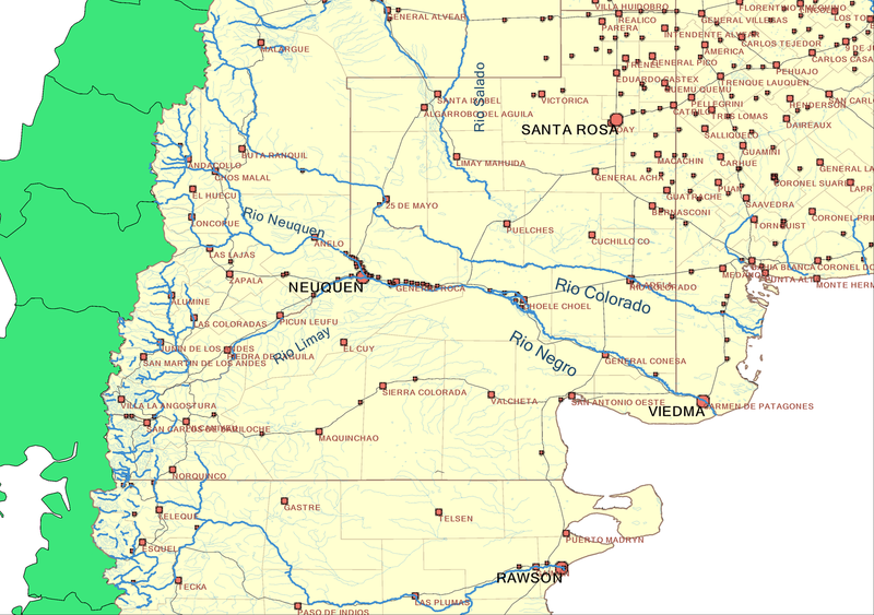
Map of Northern Patagonia, Argentina. Includes main rivers, provincial and departamental divisions, provincial capitals and heads of departments with names, and national routes (not labeled).
Created by me on September 2006. Mariano 13:05, 8 September 2006 (UTC)
Disclosure
 Map created with a number of tools including Quantum GIS, WinChips[1], and Inkscape, from data information obtained at the sources listed below.
 Mapa realizado con varias herramientas, incluidos Quantum GIS, WinChips[2], e Inkscape, en base a los datos de dominio publico, entre los cuales pueden estar las fuentes abajo citadas.
- Souces/Fuentes
- National Geophysical Data Center[3]
- Digital Map of the World Server[4]
- National Geospacial-intelligence Agency[5]
- JPL world map service[6] (via WMS)
- United Nations Environment Programme[7]
- Earth Resources Observation and Science (EROS)[8]
- USGS HydroSHEDS[9]
- Global Lakes and Wetlands Database GLWD[10]
- AeroTerra[11]
- Global Rural-Urban Mapping Project (GRUMP)[12]
- [Lehner, B. and P. Döll (2004): Development and validation of a global database of lakes, reservoirs and wetlands. Journal of Hydrology 296/1-4: 1-22.]
- Terrestrial Ecoregions GIS Database[13]
- [Olson, D. M. and E. Dinerstein. The Global 200: Priority ecoregions for global conservation. (PDF file) Annals of the Missouri Botanical Garden 89:125-126.]
ライセンス
この作品の著作権者である私は、この作品を以下のライセンスで提供します。

|
この文書は、フリーソフトウェア財団発行のGNUフリー文書利用許諾書 (GNU Free Documentation License) 1.2またはそれ以降のバージョンの規約に基づき、複製や再配布、改変が許可されます。不可変更部分、表紙、背表紙はありません。このライセンスの複製は、GNUフリー文書利用許諾書という章に含まれています。 |
| このファイルはクリエイティブ・コモンズ 表示-継承 3.0 非移植ライセンスのもとに利用を許諾されています。 | ||
| ||
| このライセンスのテンプレートは、GFDLのライセンス・アップデートによりこのファイルに追加されたものです。 |
- あなたは以下の条件に従う場合に限り、自由に
- 共有 – 本作品を複製、頒布、展示、実演できます。
- 再構成 – 二次的著作物を作成できます。
- あなたの従うべき条件は以下の通りです。
- 表示 – あなたは適切なクレジットを表示し、ライセンスへのリンクを提供し、変更があったらその旨を示さなければなりません。これらは合理的であればどのような方法で行っても構いませんが、許諾者があなたやあなたの利用行為を支持していると示唆するような方法は除きます。
- 継承 – もしあなたがこの作品をリミックスしたり、改変したり、加工した場合には、あなたはあなたの貢献部分を元の作品とこれと同一または互換性があるライセンスの下に頒布しなければなりません。
あなたは上記のライセンスから、どれか一つ以上を選択できます。
ファイルの履歴
過去の版のファイルを表示するには、その版の日時をクリックしてください。
| 日付と時刻 | サムネイル | 寸法 | 利用者 | コメント | |
|---|---|---|---|---|---|
| 現在の版 | 2017年12月22日 (金) 18:58 | | 1,731 × 1,218 (663キロバイト) | Janitoalevic | Fixed borders. |
| 2006年9月8日 (金) 13:05 |  | 1,731 × 1,218 (456キロバイト) | Marianocecowski | Map of Northern Patagonia, Argentina. Includes main rivers, provincial and departamental divisions, provincial capitals and heads of departments with names, and national routes (not labeled). Created by me on September 2006. ~~~~ {{User:Marianocecowski/ |
ファイルの使用状況
以下の 2 ページがこのファイルを使用しています:
グローバルなファイル使用状況
以下に挙げる他のウィキがこの画像を使っています:
- br.wikipedia.org での使用状況
- cs.wikipedia.org での使用状況
- de.wikipedia.org での使用状況
- el.wikipedia.org での使用状況
- en.wikipedia.org での使用状況
- eo.wikipedia.org での使用状況
- es.wikipedia.org での使用状況
- fr.wikipedia.org での使用状況
- gl.wikipedia.org での使用状況
- he.wikipedia.org での使用状況
- hr.wikipedia.org での使用状況
- hu.wikipedia.org での使用状況
- it.wikipedia.org での使用状況
- ka.wikipedia.org での使用状況
- no.wikipedia.org での使用状況
- sco.wikipedia.org での使用状況
- sh.wikipedia.org での使用状況
- uk.wikipedia.org での使用状況
- www.wikidata.org での使用状況