
ファイル:Map of Cumberland County Pennsylvania School Districts.png
高解像度版はありません。
Map_of_Cumberland_County_Pennsylvania_School_Districts.png (419 × 268 ピクセル、ファイルサイズ: 7キロバイト、MIME タイプ: image/png)
ウィキメディア・コモンズのファイルページにある説明を、以下に表示します。
|
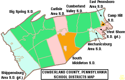
| 解説 | Map of Cumberland County, Pennsylvania, United States Public School Districts |
| 日付 | |
| 原典 | taken from US Census website [1] and modified by User:Ruhrfisch |
| 作者 | US Census, Ruhrfisch |
| 許可 (ファイルの再利用) |
US Census / US Government work is public domain, my modifications licensed under the GNU Free Documentation License |

|
この文書は、フリーソフトウェア財団発行のGNUフリー文書利用許諾書 (GNU Free Documentation License) 1.2またはそれ以降のバージョンの規約に基づき、複製や再配布、改変が許可されます。不可変更部分、表紙、背表紙はありません。このライセンスの複製は、GNUフリー文書利用許諾書という章に含まれています。 |
| このファイルはクリエイティブ・コモンズ 表示-継承 3.0 非移植ライセンスのもとに利用を許諾されています。 | ||
| ||
| このライセンスのテンプレートは、GFDLのライセンス・アップデートによりこのファイルに追加されたものです。 |
ファイルの履歴
過去の版のファイルを表示するには、その版の日時をクリックしてください。
| 日付と時刻 | サムネイル | 寸法 | 利用者 | コメント | |
|---|---|---|---|---|---|
| 現在の版 | 2008年11月6日 (木) 01:09 | | 419 × 268 (7キロバイト) | Agorist | pngcrush -brute |
| 2006年6月19日 (月) 20:19 |  | 419 × 268 (14キロバイト) | Ruhrfisch | {{Information| |Description= Map of Cumberland County, Pennsylvania, United States Public School Districts |Source= taken from US Census website [http://factfinder.census.gov/] and modified by User:Ruhrfisch |Date= June 2006 |Author= US Census, Ruhr |
ファイルの使用状況
以下のページがこのファイルを使用しています:
グローバルなファイル使用状況
以下に挙げる他のウィキがこの画像を使っています:
- en.wikipedia.org での使用状況
- Carlisle High School (Carlisle, Pennsylvania)
- Big Spring School District
- Cumberland Valley High School
- Cumberland County, Pennsylvania
- Cumberland Valley School District
- Harrisburg Academy
- South Middleton School District
- Cedar Cliff High School
- Mechanicsburg Area Senior High School
- Camp Hill School District
- Camp Hill High School
- Trinity High School (Camp Hill, Pennsylvania)
- East Pennsboro High School
- West Shore School District
- Boiling Springs High School (Pennsylvania)
- East Pennsboro Area School District
- Carlisle Area School District
- Mechanicsburg Area School District
- Shippensburg Area School District
- Red Land High School
- Template:Cumberland County, Pennsylvania School Districts
- User:Epoloch/Projects
- www.wikidata.org での使用状況