
ファイル:Strait of Gibraltar perspective.jpg

このプレビューのサイズ: 800 × 480 ピクセル。 その他の解像度: 320 × 192 ピクセル | 1,024 × 615 ピクセル | 1,528 × 917 ピクセル。
元のファイル (1,528 × 917 ピクセル、ファイルサイズ: 182キロバイト、MIME タイプ: image/jpeg)
ウィキメディア・コモンズのファイルページにある説明を、以下に表示します。
|
概要
| 解説 |
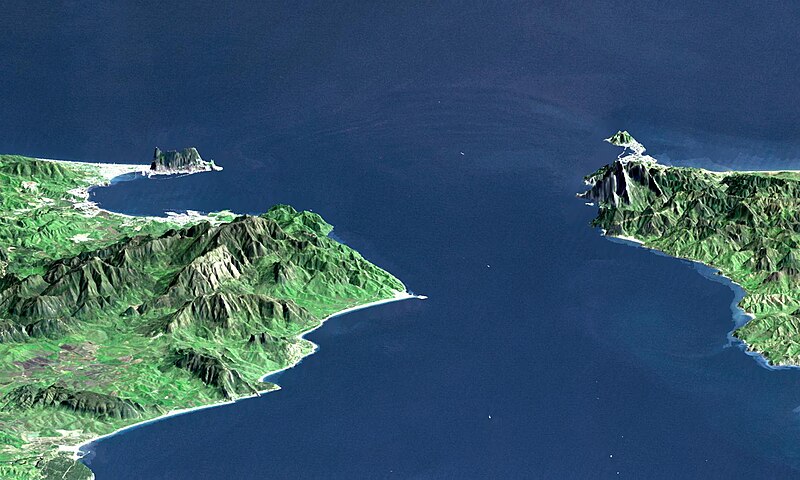
English: "This perspective view shows the Strait of Gibraltar, which is the entrance to the Mediterranean Sea from the Atlantic Ocean, with a 3-times vertical exaggeration to enhance topographic expression. Europe (Spain) is on the left. Africa (Morocco) is on the right. The Rock of Gibraltar, administered by Great Britain, is the peninsula in the back left." (quotation taken from the more detailed NASA description page)
Deutsch: Straße von Gibraltar; Aufnahme der NASA dreifach überhöht. Erstellt aus Daten von SRTM und Landsat
Français : Vue en perspective du détroit de Gibraltar ouvrant sur la mer Mediterranée avec le Maroc à droite et l'Espagne a gauche. coté espagnol on remarque le rocher de Gibraltar, en face le petit rocher est Ceuta, territoire espagnol en terre africaine.
Español: Peñón de Gibraltar |
| 日付 |
|
| 原典 | http://photojournal.jpl.nasa.gov/catalog/PIA03397 |
| 作者 | NASA / JPL / NIMA |
| その他のバージョン |
このファイルの派生的著作物: |
ライセンス
| このファイルはアメリカ航空宇宙局(NASA)によって作成されたものです。NASAの著作権の方針では、特記事項が無い場合、NASAの資料はパブリックドメインとなります。 (詳しくはTemplate:PD-USGov、NASAの著作権の方針について(英語)又はジェット推進研究所(JPL)の画像使用に関するガイドライン(英語)をご覧ください。) |
||
 |
注意事項:
|
| 注釈 | この画像には注釈がついています: コモンズで注釈を見る |
ファイルの履歴
過去の版のファイルを表示するには、その版の日時をクリックしてください。
| 日付と時刻 | サムネイル | 寸法 | 利用者 | コメント | |
|---|---|---|---|---|---|
| 現在の版 | 2005年11月14日 (月) 00:20 | | 1,528 × 917 (182キロバイト) | Oxam Hartog | en : Perspective view from the Strait of Gibraltar, Marocco is on rigth, Spain on left with the Rock of Gibraltar ahead on left. On the other side the little rock is Ceuta Spain territory on african continent fr: Vue en perspective du detroit de Gibaltar |
ファイルの使用状況
以下のページがこのファイルを使用しています:
グローバルなファイル使用状況
以下に挙げる他のウィキがこの画像を使っています:
- af.wikipedia.org での使用状況
- ar.wikipedia.org での使用状況
- azb.wikipedia.org での使用状況
- az.wikipedia.org での使用状況
- be.wikipedia.org での使用状況
- bo.wikipedia.org での使用状況
- br.wikipedia.org での使用状況
- bs.wikipedia.org での使用状況
- ca.wikipedia.org での使用状況
- ckb.wikipedia.org での使用状況
- de.wikipedia.org での使用状況
- de.wiktionary.org での使用状況
- en.wikipedia.org での使用状況
- en.wikivoyage.org での使用状況
- es.wikipedia.org での使用状況
- et.wikipedia.org での使用状況
- frr.wikipedia.org での使用状況
- fr.wikipedia.org での使用状況
- ka.wikipedia.org での使用状況
- kbd.wikipedia.org での使用状況
- ky.wikipedia.org での使用状況
- lt.wikipedia.org での使用状況
- mt.wikipedia.org での使用状況
- nl.wikipedia.org での使用状況
- pl.wiktionary.org での使用状況
- pt.wikipedia.org での使用状況
- ro.wikipedia.org での使用状況
- ru.wikipedia.org での使用状況
- ru.wiktionary.org での使用状況
- sl.wikipedia.org での使用状況
- sw.wikipedia.org での使用状況
- uk.wikipedia.org での使用状況
- uz.wikipedia.org での使用状況
このファイルのグローバル使用状況を表示する。