
ファイル:Uruguay fisico.png

このプレビューのサイズ: 471 × 599 ピクセル。 その他の解像度: 188 × 240 ピクセル | 377 × 480 ピクセル | 603 × 768 ピクセル | 1,100 × 1,400 ピクセル。
元のファイル (1,100 × 1,400 ピクセル、ファイルサイズ: 209キロバイト、MIME タイプ: image/png)
ウィキメディア・コモンズのファイルページにある説明を、以下に表示します。
|

|
この地図画像は、ベクターイメージである SVG ファイルとして再作成されるべきです。これにはいくつかの利点があります。詳しくはCommons:Media for cleanupを参照してください。この画像の SVG 形式がすでに利用可能である場合は、アップロードしてください。アップロード後、この画像にあるこのテンプレートを{{Vector version available|新しい画像ファイル名.svg}}テンプレートで置き換えてください。
|
概要
| 解説 |
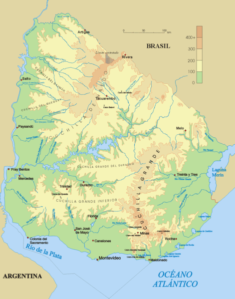
Español: Mapa físico de Uruguay.
English: Topographical map of Uruguay |
| 日付 | |
| 原典 | 投稿者自身による著作物 |
| 作者 | Jordevi |
| その他のバージョン |
|

ライセンス
| この著作物の著作権者である私は、この著作物における権利を放棄しパブリックドメインとします。これは全世界で適用されます。 一部の国では、これが法的に可能ではない場合があります。その場合は、次のように宣言します。 私は、あらゆる人に対して、法により必要とされている条件を除き、如何なる条件も課すことなく、あらゆる目的のためにこの著作物を使用する権利を与えます。 |
ファイルの履歴
過去の版のファイルを表示するには、その版の日時をクリックしてください。
| 日付と時刻 | サムネイル | 寸法 | 利用者 | コメント | |
|---|---|---|---|---|---|
| 現在の版 | 2006年12月28日 (木) 03:48 | | 1,100 × 1,400 (209キロバイト) | Jordevi | Mapa físico de Uruguay. Category:Maps of Uruguay |
ファイルの使用状況
以下の 3 ページがこのファイルを使用しています:
グローバルなファイル使用状況
以下に挙げる他のウィキがこの画像を使っています:
- an.wikipedia.org での使用状況
- arz.wikipedia.org での使用状況
- ast.wikipedia.org での使用状況
- bg.wikipedia.org での使用状況
- ca.wikipedia.org での使用状況
- ceb.wikipedia.org での使用状況
- cs.wikipedia.org での使用状況
- de.wikipedia.org での使用状況
- Cuchilla de Haedo
- Cuchilla Grande
- Río Negro (Uruguay)
- Sierra Carapé
- Río Yí
- Río Tacuarembó
- Río Arapey
- Río Daymán
- Rio Quaraí
- Río Queguay
- Río Queguay Chico
- Río San Salvador
- Río Rosario
- Río Tacuarí
- Río San Juan (Uruguay)
- Río Cebollatí
- Río Arapey Chico
- Rio Jaguarão
- Río San José
- Sierra de las Ánimas
- Arroyo de la India
- Río Olimar
- Río Santa Lucía (Uruguay)
- Arroyo Grande (Río Negro, rechtsseitig)
- Benutzer:Gniesgnatz/baustelle
- en.wikipedia.org での使用状況
- es.wikipedia.org での使用状況
このファイルのグローバル使用状況を表示する。