
ファイル:1827 Finley Map of Africa - Geographicus - Africa-finley-1827.jpg
このプレビューのサイズ: 466 × 599 ピクセル。 その他の解像度: 186 × 240 ピクセル | 373 × 480 ピクセル | 597 × 768 ピクセル | 796 × 1,024 ピクセル | 2,332 × 3,000 ピクセル。
元のファイル (2,332 × 3,000 ピクセル、ファイルサイズ: 1.97メガバイト、MIME タイプ: image/jpeg)
ウィキメディア・コモンズのファイルページにある説明を、以下に表示します。
|
| Anthony Finley: Africa.
( |
||||||
|---|---|---|---|---|---|---|
| 作者 | ||||||
| タイトル |
Africa. |
|||||
| 解説 |
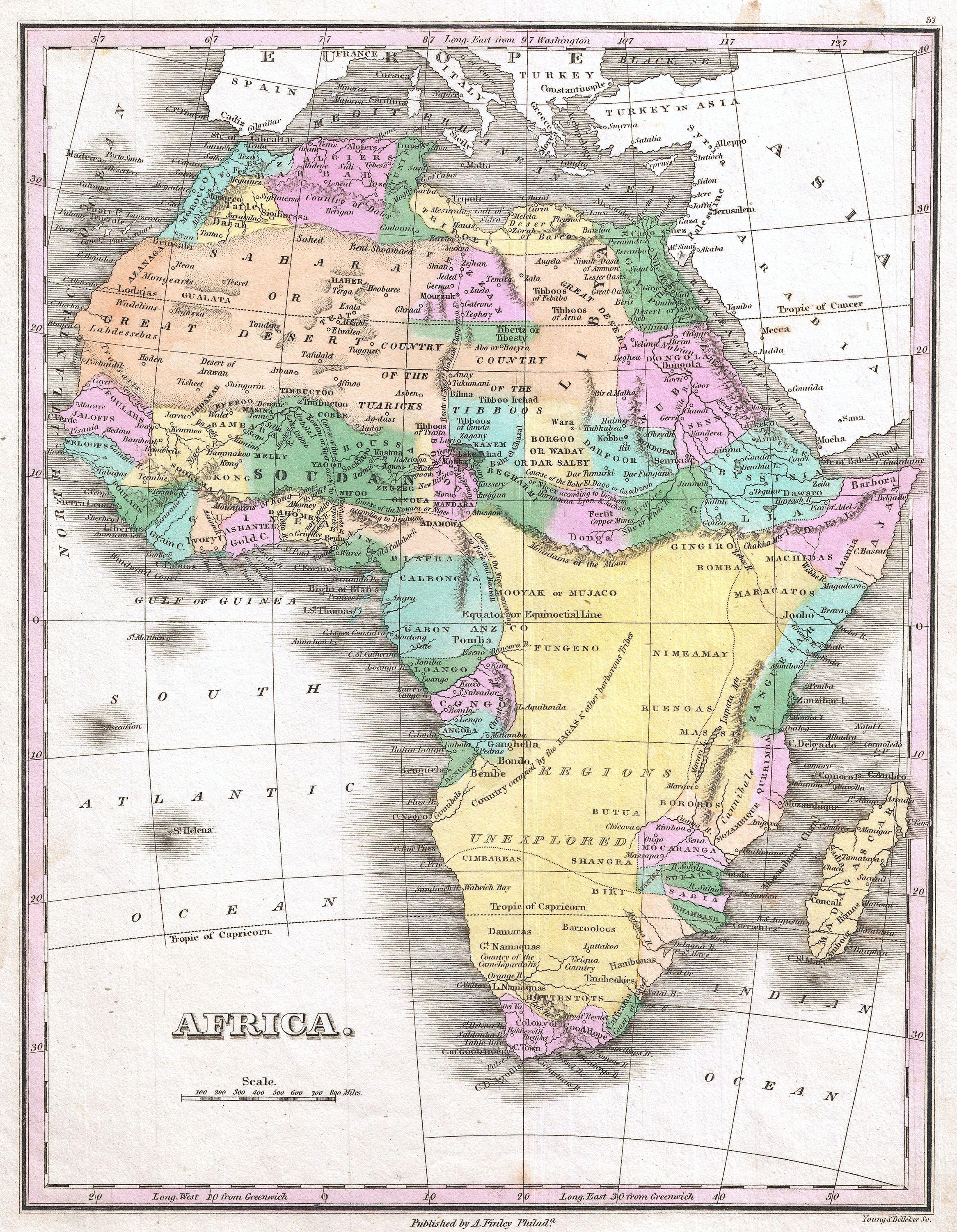
Afrikaans: 'n Pragtige voorbeeld van Anthony Finley se invloedryke kaart van Afrika, wat deur Young en Delleker gegraveer is vir die 1827-uitgawe van Finley se General Atlas. Die titel en skaal is links onder. Hierdie uitsonderlike kaart het die sterk eskalasie in verkenning van Afrika tydens die mid-19de eeu voorafgegaan, en die binneland van Afrika bly hier grotendeels onbekend. Die Ptolemaïese Berge van die Maan word aangedui as 'n bergreeks wat wes na oos oor die sentrale deel van die kontinent strek, met die suggestie dat verskeie takke van die Nyl hier ontspring. Verskeie spekulatiewe lope van die Nigerrivier word aangedui, met een wat by die Nyl aansluit, 'n ander wat suid van die Berge van die Maan die Kongo binnevloei, en nog 'n ander wat korrek getoon word met 'n kromming na 'n monding in die Golf van Bonny / Biafra. Regdeur word etlike etniese groepe aangedui, waaronder die Pomba, Jaga, Timboektoe, Toeareg, Tibboe, Bambara en ander. Ook word 'n land van kannibale in Mosambiek onderskei.
English: A beautiful example of Finley's important 1827 map of Africa. This uncommon map predates the explosion of African exploration that occurred in the mid 19th century. Much of the interior remains unknown. The Ptolemaic Mountains of the Moon are drawn stretching across the central part of the continent with the suggestions that they are the source of several branches of the Nile. Several speculative courses are drawn for the Niger River, one of which joins it to the Nile, another of which flows south of the Mountains of the Moon into the Congo, and yet another of which, correctly, bends southwards to empty into the Bight of Biafra. It identifies numerous African tribes throughout, including the Pomba, Jaga, Timbuctoo, Tuareg, Tibboos, Bambara, and others. It also identifies a land of cannibals in Mozambique. Title and scale in lower left quadrant. Engraved by Young and Delleker for the 1827 edition of Anthony Finley's General Atlas. |
|||||
| 日付 | 1827年 (undated) | |||||
| 寸法 | 高さ: 11.5 in (29.2 cm);幅: 9 in (22.8 cm) | |||||
| 台帳番号 |
Geographicus link: Africa-finley-1827 |
|||||
| 情報源/撮影者 |
Finley, Anthony, A New General Altas, Comprising a Complete Set of Maps, representing the Grand Divisions of the Globe, Together with the several Empires, Kingdoms and States in the World; Compiled from the Best Authorities, and corrected by the Most Recent Discoveries, Philadelphia, 1827.
|
|||||
| 許可 (ファイルの再利用) |
|
|||||
| その他のバージョン |
 |
|||||
ファイルの履歴
過去の版のファイルを表示するには、その版の日時をクリックしてください。
| 日付と時刻 | サムネイル | 寸法 | 利用者 | コメント | |
|---|---|---|---|---|---|
| 現在の版 | 2011年3月23日 (水) 09:50 | | 2,332 × 3,000 (1.97メガバイト) | BotMultichillT | {{subst:User:Multichill/Geographicus |link=http://www.geographicus.com/P/AntiqueMap/Africa-finley-1827 |product_name=1827 Finley Map of Africa |map_title=Africa. |description=A beautiful example of Finley's important 1827 map of Africa. This uncommon ma |
ファイルの使用状況
以下のページがこのファイルを使用しています:
グローバルなファイル使用状況
以下に挙げる他のウィキがこの画像を使っています:
- azb.wikipedia.org での使用状況
- ca.wikipedia.org での使用状況
- de.wikipedia.org での使用状況
- en.wikipedia.org での使用状況
- es.wikipedia.org での使用状況
- fr.wikipedia.org での使用状況
- it.wikipedia.org での使用状況
- ru.wikipedia.org での使用状況
- tr.wikipedia.org での使用状況