
ファイル:Ash Plume from Tavurvur, Papua New Guinea.jpg

このプレビューのサイズ: 534 × 599 ピクセル。 その他の解像度: 214 × 240 ピクセル | 428 × 480 ピクセル | 685 × 768 ピクセル | 1,183 × 1,327 ピクセル。
元のファイル (1,183 × 1,327 ピクセル、ファイルサイズ: 241キロバイト、MIME タイプ: image/jpeg)
ウィキメディア・コモンズのファイルページにある説明を、以下に表示します。
|
概要
| 解説 |
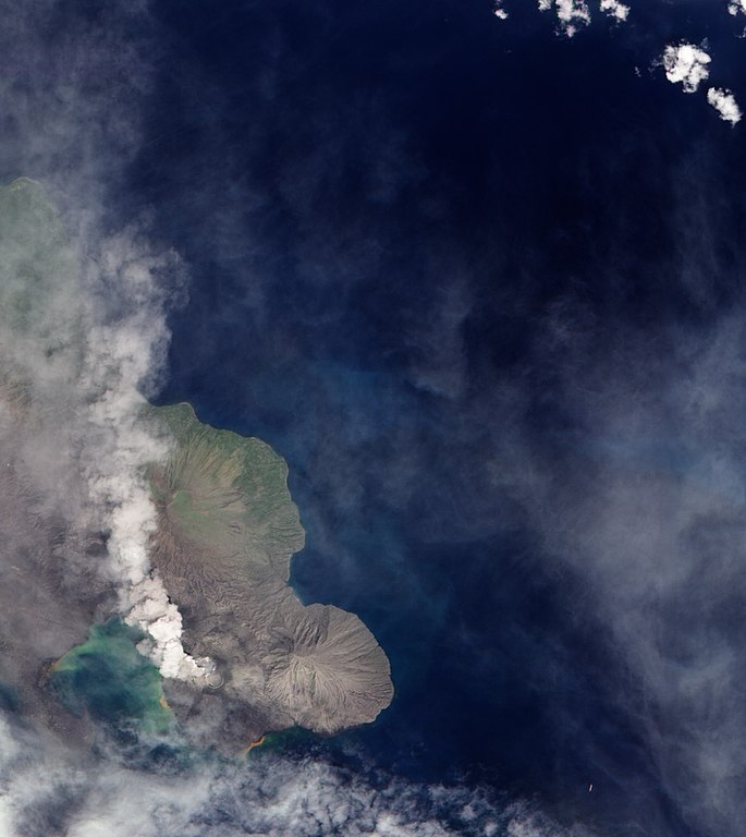
English: A 1994 eruption which buried Rabaul involved the currently active Tavurvur Cone as well as Vulcan Cone, located across Blanche Bay to the south-west (not pictured). The city of Rabaul is located on the peninsula across the Great Harbor from Tavurvur. More than a foot of ash fell on parts of the city, and combined with rain, it collapsed many of the small city’s buildings and houses. White dots on the peninsula may be buildings or building sites. |
| 日付 | |
| 原典 | NASA Earth Observatory |
| 作者 | Robert Simmon |
Image captured by the Advanced Land Imager on NASA’s Earth Observing-1 (EO-1) satellite. Image created using EO-1 ALI data provided by the NASA EO-1 team. Instrument: EO-1 - ALI
ライセンス
| このファイルはアメリカ航空宇宙局(NASA)によって作成されたものです。NASAの著作権の方針では、特記事項が無い場合、NASAの資料はパブリックドメインとなります。 (詳しくはTemplate:PD-USGov、NASAの著作権の方針について(英語)又はジェット推進研究所(JPL)の画像使用に関するガイドライン(英語)をご覧ください。) |
||
 |
注意事項:
|
| 注釈 | この画像には注釈がついています: コモンズで注釈を見る |
ファイルの履歴
過去の版のファイルを表示するには、その版の日時をクリックしてください。
| 日付と時刻 | サムネイル | 寸法 | 利用者 | コメント | |
|---|---|---|---|---|---|
| 現在の版 | 2009年12月8日 (火) 13:04 | | 1,183 × 1,327 (241キロバイト) | Originalwana | {{Information |Description={{en|1=A 1994 eruption which buried Rabaul involved the currently active Tavurvur Cone as well as Vulcan Cone, located across Blanche Bay to the south-west (not pictured). The city of Rabaul is located on the peninsula acros |
ファイルの使用状況
以下のページがこのファイルを使用しています:
グローバルなファイル使用状況
以下に挙げる他のウィキがこの画像を使っています:
- br.wikipedia.org での使用状況
- en.wikipedia.org での使用状況
- fa.wikipedia.org での使用状況
- hu.wikipedia.org での使用状況
- id.wikipedia.org での使用状況
- it.wikipedia.org での使用状況
- ko.wikipedia.org での使用状況
- pt.wikipedia.org での使用状況
- uk.wikipedia.org での使用状況
- zh.wikipedia.org での使用状況