
ファイル:Bingöl districts.png

このプレビューのサイズ: 776 × 600 ピクセル。 その他の解像度: 311 × 240 ピクセル | 621 × 480 ピクセル | 994 × 768 ピクセル | 1,056 × 816 ピクセル。
元のファイル (1,056 × 816 ピクセル、ファイルサイズ: 24キロバイト、MIME タイプ: image/png)
ウィキメディア・コモンズのファイルページにある説明を、以下に表示します。
|
概要
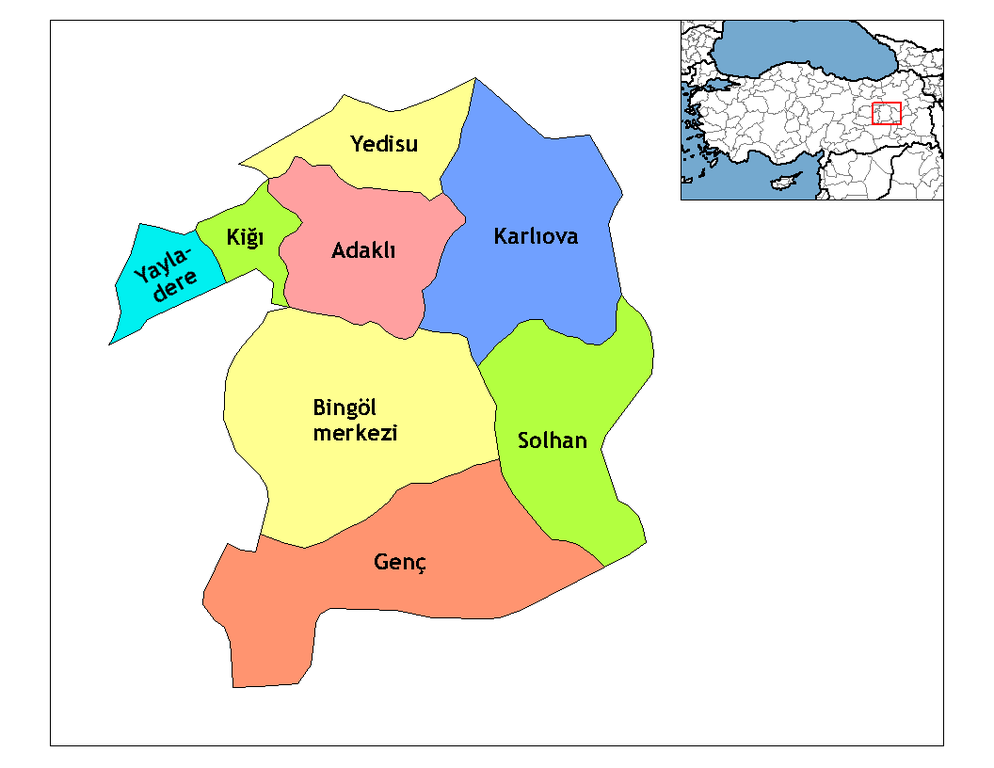
| 解説 | Map of the districts of Bingöl province in Turkey. Created by Rarelibra 18:56, 1 December 2006 (UTC) for public domain use, using MapInfo Professional v8.5 and various mapping resources. Edited by One Homo Sapiens Corrected text where İ,Ş,ı,ğ,or ş occurs in name. Source: [statoids-com]. Increased font size and enhanced color differences among adjacent districts. |
| 日付 | 2007年3月31日 (当初のアップロード日) |
| 原典 | コンピュータが読み取れる情報は提供されていませんが、投稿者自身による著作物だと推定されます(著作権の主張に基づく) |
| 作者 | コンピュータが読み取れる情報は提供されていませんが、Denizz~commonswikiだと推定されます(著作権の主張に基づく) |
ライセンス
| この著作物の著作権者である私は、この著作物における権利を放棄しパブリックドメインとします。これは全世界で適用されます。 一部の国では、これが法的に可能ではない場合があります。その場合は、次のように宣言します。 私は、あらゆる人に対して、法により必要とされている条件を除き、如何なる条件も課すことなく、あらゆる目的のためにこの著作物を使用する権利を与えます。 |
ファイルの履歴
過去の版のファイルを表示するには、その版の日時をクリックしてください。
| 日付と時刻 | サムネイル | 寸法 | 利用者 | コメント | |
|---|---|---|---|---|---|
| 現在の版 | 2008年12月28日 (日) 21:10 | | 1,056 × 816 (24キロバイト) | One Homo Sapiens | Corrected text where İ,Ş,ı,ğ,or ş occurs in name. Source: [statoids-com]. Increased font size and enhanced color differences among adjacent districts. |
| 2007年3月31日 (土) 06:50 |  | 1,056 × 816 (25キロバイト) | Denizz~commonswiki | == Summary == Map of the districts of Bingol province in Turkey. Created by Rarelibra 18:56, 1 December 2006 (UTC) for public domain use, using MapInfo Professional v8.5 and various mapping resources. == Licensing == {{PD-self}} <!-- |
ファイルの使用状況
以下のページがこのファイルを使用しています:
グローバルなファイル使用状況
以下に挙げる他のウィキがこの画像を使っています:
- ar.wikipedia.org での使用状況
- ast.wikipedia.org での使用状況
- ca.wikipedia.org での使用状況
- cs.wikipedia.org での使用状況
- de.wikipedia.org での使用状況
- Yayladere
- Kiğı
- Yedisu
- Vorlage:Navigationsleiste Landkreise der Provinz Bingöl
- Adaklı
- Bingöl
- Genç (Bingöl)
- Karlıova
- Solhan (Türkei)
- Çatalkaya
- Dallıca
- Eskikavak
- Güneyağıl
- Kutluca
- Demirdöş
- Yorgançayır
- Yazgünü
- Açıkgüney
- Ağaçöven
- Alınyazı
- Aşağıserinyer
- Aşağıyağmurlu
- Aydınlar (Yayladere)
- Batıayaz
- Çalıkağıl
- Çayağzı
- Dalbasan
- Doğucak
- Gökçedal
- Günlük
- Haktanır
- Kalkanlı
- Kırköy
- Korlu
- Vorlage:Navigationsleiste Ortschaften im Landkreis Yayladere
- Sarıtosun
- Sürmelikoç (Yayladere)
- Yavuztaş
- Yaylabağ
- Zeynelli
- Vorlage:Navigationsleiste Ortschaften im Landkreis Kiğı
- Baklalı
- Bilekkaya
- Güneşlik
- Çiçektepe
- Darköprü
このファイルのグローバル使用状況を表示する。