
ファイル:Louisiana regions map.svg

この SVG ファイルのこの PNG プレビューのサイズ: 666 × 599 ピクセル. その他の解像度: 267 × 240 ピクセル | 534 × 480 ピクセル | 854 × 768 ピクセル | 1,138 × 1,024 ピクセル | 2,276 × 2,048 ピクセル | 5,018 × 4,515 ピクセル。
元のファイル (SVG ファイル、5,018 × 4,515 ピクセル、ファイルサイズ: 557キロバイト)
ウィキメディア・コモンズのファイルページにある説明を、以下に表示します。
|
frenchjjisjisjfisf== 概要 ==
| 解説 |
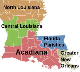
English: Map of Louisiana's regions (English) Français : Une carte des régions de la Louisiane (Anglais) |
| 日付 | |
| 原典 | Based on Image:Map of Louisiana highlighting Jefferson Davis Parish.svg, colors filled in based on data from University of Louisiana at Lafayette Center for Cultural and Eco-Tourism |
| 作者 |
ライセンス
| この著作物の著作権者である私は、この著作物における権利を放棄しパブリックドメインとします。これは全世界で適用されます。 一部の国では、これが法的に可能ではない場合があります。その場合は、次のように宣言します。 私は、あらゆる人に対して、法により必要とされている条件を除き、如何なる条件も課すことなく、あらゆる目的のためにこの著作物を使用する権利を与えます。 |
ファイルの履歴
過去の版のファイルを表示するには、その版の日時をクリックしてください。
| 日付と時刻 | サムネイル | 寸法 | 利用者 | コメント | |
|---|---|---|---|---|---|
| 現在の版 | 2006年12月22日 (金) 09:09 | | 5,018 × 4,515 (557キロバイト) | Interiot~commonswiki | rm stroke from small islands so they're not so invisible |
| 2006年12月21日 (木) 20:47 |  | 5,018 × 4,515 (557キロバイト) | Interiot~commonswiki | rearrange colors again | |
| 2006年12月21日 (木) 20:36 |  | 5,018 × 4,515 (557キロバイト) | Interiot~commonswiki | rearrange colors again | |
| 2006年12月21日 (木) 20:30 |  | 5,018 × 4,515 (535キロバイト) | Interiot~commonswiki | change around the green and the off-gray | |
| 2006年12月21日 (木) 20:18 |  | 5,018 × 4,515 (498キロバイト) | Interiot~commonswiki | {{SVG}} {{Information |Description=Map over Louisiana's regions |Source=Based on Image:Map of Louisiana highlighting Jefferson Davis Parish.svg, colors filled in based on data from [http://ccet.louisiana.edu/03a_Cultural_Tourism_Files/01.00_The_Land. |
ファイルの使用状況
以下のページがこのファイルを使用しています:
グローバルなファイル使用状況
以下に挙げる他のウィキがこの画像を使っています:
- ar.wikipedia.org での使用状況
- cy.wikipedia.org での使用状況
- da.wikipedia.org での使用状況
- en.wikipedia.org での使用状況
- en.wiktionary.org での使用状況
- fi.wikipedia.org での使用状況
- fr.wikipedia.org での使用状況
- gl.wikipedia.org での使用状況
- gu.wikipedia.org での使用状況
- hu.wikipedia.org での使用状況
- it.wikipedia.org での使用状況
- kn.wikipedia.org での使用状況
- pl.wikipedia.org での使用状況
- pt.wikipedia.org での使用状況
- ro.wikipedia.org での使用状況
- simple.wikipedia.org での使用状況
- vi.wikipedia.org での使用状況
- zh.wikipedia.org での使用状況