
ファイル:Mackinac Island topographic map-en.svg

この SVG ファイルのこの PNG プレビューのサイズ: 545 × 600 ピクセル. その他の解像度: 218 × 240 ピクセル | 436 × 480 ピクセル | 698 × 768 ピクセル | 931 × 1,024 ピクセル | 1,862 × 2,048 ピクセル | 1,200 × 1,320 ピクセル。
元のファイル (SVG ファイル、1,200 × 1,320 ピクセル、ファイルサイズ: 457キロバイト)
ウィキメディア・コモンズのファイルページにある説明を、以下に表示します。
|
概要
| カメラの位置 | | 以下のサービスでこの位置を確認する: オープンストリートマップ |
|---|
| 解説 |
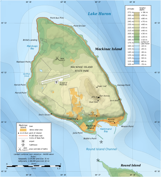
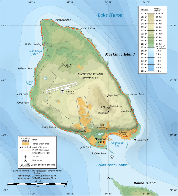
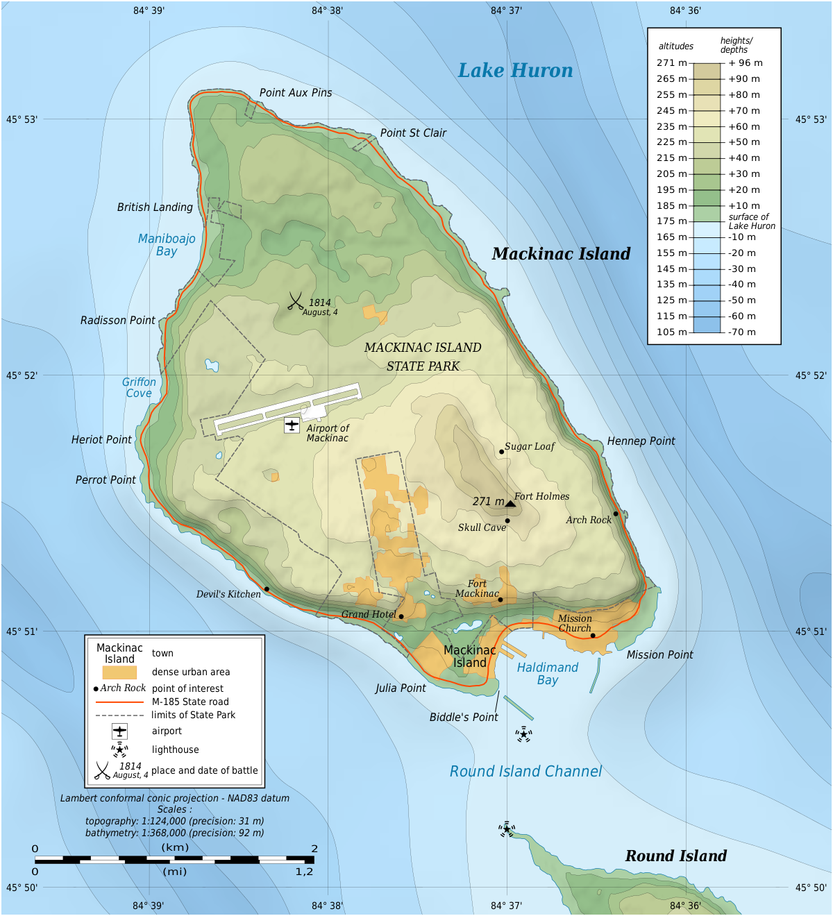
English: Topographic map in English of Mackinac Island, Lake Huron, Michigan, USA.
Note: The shaded relief is a raster image embedded in the SVG file. Français : Carte topographique en anglais de l'Île Mackinac, Lac Huron, Michigan, États-Unis. Note : Les ombres du relief sont une image bitmap embarquée dans le fichier SVG. Lambert conformal conic projection – NAD83 datum
|
||
| 日付 | |||
| 原典 |
投稿者自身による著作物
|
||
| 作者 | Eric Gaba (Sting - fr:Sting) | ||
| 許可 (ファイルの再利用) |
|
||
| その他のバージョン |
|


|
このSVGファイルには翻訳可能な埋め込みテキストが含まれています。SVG翻訳ツールや他のSVGエディタを使用して自分の言語に翻訳可能です。詳しくはSVGファイルの翻訳についてを参照してください。 |
ライセンス
この作品の著作権者である私は、この作品を以下のライセンスで提供します。

|
この文書は、フリーソフトウェア財団発行のGNUフリー文書利用許諾書 (GNU Free Documentation License) 1.2またはそれ以降のバージョンの規約に基づき、複製や再配布、改変が許可されます。不可変更部分、表紙、背表紙はありません。このライセンスの複製は、GNUフリー文書利用許諾書という章に含まれています。 |
このファイルはクリエイティブ・コモンズ 表示-継承 3.0 非移植ライセンスのもとに利用を許諾されています。
- あなたは以下の条件に従う場合に限り、自由に
- 共有 – 本作品を複製、頒布、展示、実演できます。
- 再構成 – 二次的著作物を作成できます。
- あなたの従うべき条件は以下の通りです。
- 表示 – あなたは適切なクレジットを表示し、ライセンスへのリンクを提供し、変更があったらその旨を示さなければなりません。これらは合理的であればどのような方法で行っても構いませんが、許諾者があなたやあなたの利用行為を支持していると示唆するような方法は除きます。
- 継承 – もしあなたがこの作品をリミックスしたり、改変したり、加工した場合には、あなたはあなたの貢献部分を元の作品とこれと同一または互換性があるライセンスの下に頒布しなければなりません。
あなたは上記のライセンスから、どれか一つ以上を選択できます。
ファイルの履歴
過去の版のファイルを表示するには、その版の日時をクリックしてください。
| 日付と時刻 | サムネイル | 寸法 | 利用者 | コメント | |
|---|---|---|---|---|---|
| 現在の版 | 2010年7月7日 (水) 17:43 | | 1,200 × 1,320 (457キロバイト) | Liandrei | fix |
| 2010年7月7日 (水) 17:39 |  | 1,196 × 1,316 (133キロバイト) | Liandrei | fix | |
| 2010年7月7日 (水) 17:35 |  | 1,196 × 1,316 (133キロバイト) | Liandrei | Removed border | |
| 2009年6月9日 (火) 01:37 |  | 1,200 × 1,320 (462キロバイト) | Sting | == Summary == {{Location|45|51|53|N|84|37|30|W|scale:30000}} {{Information| |Description={{en|Topographic map in English of Mackinac Island, Lake Huron, Michigan, USA.<br/>''Note: The shaded relief is a raster image embedded in th |
ファイルの使用状況
グローバルなファイル使用状況
以下に挙げる他のウィキがこの画像を使っています:
- ca.wikipedia.org での使用状況
- de.wikipedia.org での使用状況
- en.wikipedia.org での使用状況
- Mackinac Island
- Fort Mackinac
- Fort Holmes
- Mackinac Island State Park
- Andrew Holmes (army officer)
- Battle of Mackinac Island (1814)
- Mission House (Mackinac Island)
- Arch Rock (Mackinac Island)
- Round Island Light, Michigan
- Marquette Park (Mackinac Island)
- Round Island Passage Light
- Wikipedia:Graphics Lab/Photography workshop/Archive/Jul 2010
- Portal:Islands/Selected article
- Portal:Islands/Selected article/55
- en.wikivoyage.org での使用状況
- es.wikipedia.org での使用状況
- fr.wikipedia.org での使用状況
- kk.wikipedia.org での使用状況
- nl.wikipedia.org での使用状況
- pl.wikipedia.org での使用状況
- ru.wikipedia.org での使用状況
- www.wikidata.org での使用状況
- xmf.wikipedia.org での使用状況
- zh.wikipedia.org での使用状況