
ファイル:Map of the Arctic region showing the Northeast Passage, the Northern Sea Route and Northwest Passage, and bathymetry.png

このプレビューのサイズ: 632 × 600 ピクセル。 その他の解像度: 253 × 240 ピクセル | 506 × 480 ピクセル | 1,003 × 952 ピクセル。
元のファイル (1,003 × 952 ピクセル、ファイルサイズ: 758キロバイト、MIME タイプ: image/png)
ウィキメディア・コモンズのファイルページにある説明を、以下に表示します。
|
概要
| 解説 |
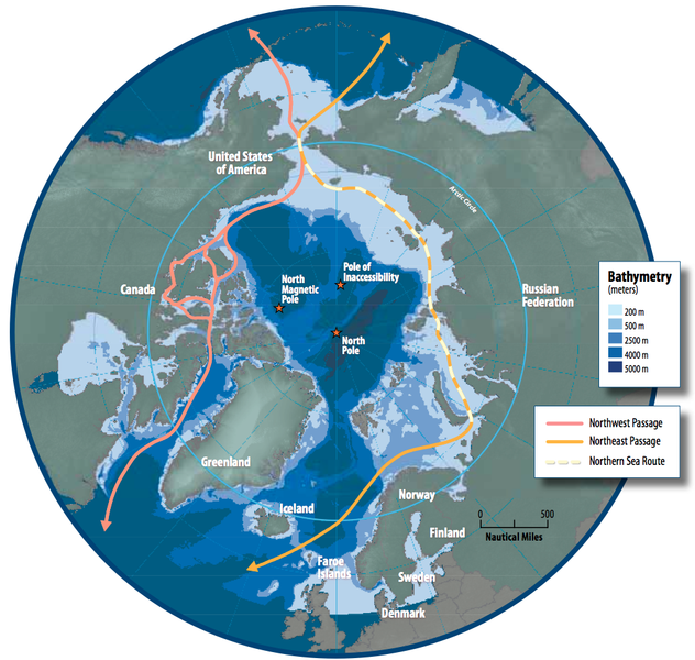
English: Map of the Arctic region showing shipping routes Northeast Passage, Northern Sea Route, and Northwest Passage, and bathymetry |
| 日付 | |
| 原典 | Arctic Council - Arctic marine shipping assessment - http://www.arctic.noaa.gov/detect/documents/AMSA_2009_Report_2nd_print.pdf |
| 作者 | Susie Harder |
ライセンス
この作品は、次の理由でパブリックドメインに属します。the work was created/published by the Arctic Council, an international organization
パブリックドメインの適用が法的に不可能な場合: 誰でも、いかなる目的であっても、法令によって要求される条件以外のいかなる条件も課されることなしに、この作品を利用する権利が認められます。 上記で説明されている理由が、コモンズのライセンス方針に準拠しているかどうか検証してください。
|
ファイルの履歴
過去の版のファイルを表示するには、その版の日時をクリックしてください。
| 日付と時刻 | サムネイル | 寸法 | 利用者 | コメント | |
|---|---|---|---|---|---|
| 現在の版 | 2014年10月19日 (日) 16:46 | | 1,003 × 952 (758キロバイト) | Al83tito | User created page with UploadWizard |
ファイルの使用状況
以下のページがこのファイルを使用しています:
グローバルなファイル使用状況
以下に挙げる他のウィキがこの画像を使っています:
- bn.wikipedia.org での使用状況
- de.wikipedia.org での使用状況
- en.wikipedia.org での使用状況
- es.wikipedia.org での使用状況
- fa.wikipedia.org での使用状況
- fr.wikipedia.org での使用状況
- he.wikipedia.org での使用状況
- hr.wikipedia.org での使用状況
- hu.wikipedia.org での使用状況
- id.wikipedia.org での使用状況
- it.wikipedia.org での使用状況
- ko.wikipedia.org での使用状況
- nl.wikipedia.org での使用状況
- pl.wikipedia.org での使用状況
- pt.wikipedia.org での使用状況
- ru.wikipedia.org での使用状況
- sd.wikipedia.org での使用状況
- te.wikipedia.org での使用状況
- th.wikipedia.org での使用状況
- tr.wikipedia.org での使用状況