
ファイル:MarsPanoramaa.jpg

元のファイル (10,000 × 1,248 ピクセル、ファイルサイズ: 11.49メガバイト、MIME タイプ: image/jpeg)
ウィキメディア・コモンズのファイルページにある説明を、以下に表示します。
|
概要
| 解説 |
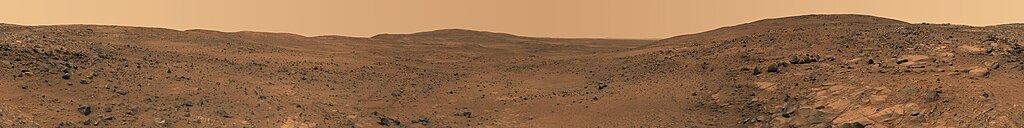
English: Descent from the Summit of 'Husband Hill'
In late November 2005 while descending "Husband Hill", NASA's Mars Exploration Rover Spirit took the most detailed panorama so far of the "Inner Basin", the rover's next target destination. Spirit acquired the 405 individual images that make up this 360-degree view of the surrounding terrain using five different filters on the panoramic camera. The rover took the images on Martian days, or sols, 672 to 677 (23 to 28 Nov. 2005). Français : Vue prise en descendant « Husband Hills », sur Mars. Panorama de 360° obtenu en assemblant 405 photos prises entre le 23 et le 28 novembre 2005 par l'astromobile Spirit de la NASA. Ce panorama est l'image la plus précise de l'« Inner Bassin ». On peut voir en explorant ce panorama en détail les pistes tracées par Spirit lors de son ascension de la colline. |
| 日付 | Nov. 23-28, 2005 |
| 原典 | NASA Jet Propulsion Laboratory[1] |
| 作者 | NASA |
| その他のバージョン | Restored version of Image:MarsPanorama.jpg with cropping to remove blank patches and minor changes to address stitching flaws. |
| 360° | View in 360° panoramic viewer
|
|---|
|

この画像は2011年1月12日の今日の一枚に選ばれました。その際の説明文は以下のとおりでした。 日本語: 火星のハズバンド・ヒル頂上からの下り坂。無人探査機スピリットによる撮影。 他の言語
Dansk: Nedkørsel fra toppen af "Husband Hill", en af Columbia-bakkerne i Gusevkrateret i Aeolis quadranglen (180-225° V, 0-30° S) på Mars. Optaget af den ubemandede rumsonde Spirit (en MER) fra 23.-28. november 2005 (Mars soltid, dag 672-677). English: Descent from the Summit of 'Husband Hill', panorama by Spirit Rover taken in 2005. Español: Descenso desde la cima de Husband Hill. Panorámica tomada por el Spirit a finales de noviembre de 2005 en Marte. Italiano: Discesa dalla sommità della collina Husband Hill su Marte ripresa dal rover Spirit durante la sua missione nel 2005. Magyar: Marsi tájkép a Husband Hill-ről nézve Nederlands: Afdaling van de kruin van de Husband Hill, een van de Columbia Hills in de Gusevkrater in het Aeolis-quadrangle (180-225° W, 0-30° Z) van Mars. Panorama gemaakt door het onbemande ruimtevaartuig Spirit (een MER) op 23 tot 28 november 2005 (sol/Martiaanse zonnedag 672 tot 677). Українська: Кругова панорама з вершини Пагорба Хазбенд на Марсі, світлини зроблені марсоходом «Спірит» 23 - 28 листопада 2005 р. 日本語: 火星のハズバンド・ヒル頂上からの下り坂。無人探査機スピリットによる撮影。 |
ライセンス
| このファイルはアメリカ航空宇宙局(NASA)によって作成されたものです。NASAの著作権の方針では、特記事項が無い場合、NASAの資料はパブリックドメインとなります。 (詳しくはTemplate:PD-USGov、NASAの著作権の方針について(英語)又はジェット推進研究所(JPL)の画像使用に関するガイドライン(英語)をご覧ください。) |
||
 |
注意事項:
|
ファイルの履歴
過去の版のファイルを表示するには、その版の日時をクリックしてください。
| 日付と時刻 | サムネイル | 寸法 | 利用者 | コメント | |
|---|---|---|---|---|---|
| 現在の版 | 2008年3月1日 (土) 06:40 | 10,000 × 1,248 (11.49メガバイト) | Durova | {{Information |Description= |Source= |Date= |Author= |Permission= |other_versions= }} | |
| 2008年3月1日 (土) 06:27 | 7,000 × 874 (5.9メガバイト) | Durova | {{Information |Description= |Source=self-made |Date= |Author= Durova |Permission= |other_versions= }} | ||
| 2008年3月1日 (土) 06:00 | 5,500 × 686 (2.1メガバイト) | Durova | {{Information |Description=Descent from the Summit of 'Husband Hill' In late November 2005 while descending "Husband Hill," NASA's Mars Exploration Rover Spirit took the most detailed panorama so far of the "Inner Basin," the rover's next target destinat |
ファイルの使用状況
グローバルなファイル使用状況
以下に挙げる他のウィキがこの画像を使っています:
- ar.wikipedia.org での使用状況
- ba.wikipedia.org での使用状況
- be-tarask.wikipedia.org での使用状況
- be.wikipedia.org での使用状況
- bg.wikipedia.org での使用状況
- bn.wikipedia.org での使用状況
- crh.wikipedia.org での使用状況
- cv.wikipedia.org での使用状況
- da.wikipedia.org での使用状況
- en.wikipedia.org での使用状況
- Mars rover
- Husband Hill
- User:Kotra
- Portal:Solar System
- Portal:Solar System/Selected picture
- User:Darkieboy236
- Wikipedia:WikiProject Media Restoration/Landmark images
- Wikipedia:Featured pictures thumbs/10
- Wikipedia:Featured picture candidates/March-2008
- Wikipedia:Featured picture candidates/Mars panorama
- Wikipedia:Wikipedia Signpost/2008-03-13/Features and admins
- User talk:Durova/Archive 53
- User:Orion11M87
- Wikipedia:Picture of the day/September 2008
- Template:POTD/2008-09-12
- Wikipedia:Wikipedia Signpost/2008-03-13/SPV
- User talk:Durova/Archive 62
- User:Durova/Featured credits at the Turkish language Wikipedia
- User:Darkieboy236/Sandbox
- User:Durova/Featured picture gallery/2008
- Portal:Outer space/Selected picture
- Portal:Outer space/Selected picture/28
- Wikipedia:Featured pictures/Space/Panorama
- Wikipedia:Wikipedia Signpost/Single/2008-03-13
- en.wikiversity.org での使用状況
- es.wikipedia.org での使用状況
- fa.wikipedia.org での使用状況
- fr.wikipedia.org での使用状況
- hu.wikipedia.org での使用状況
このファイルのグローバル使用状況を表示する。