
ファイル:Mitchell map michigan.jpg
このプレビューのサイズ: 597 × 600 ピクセル。 その他の解像度: 239 × 240 ピクセル | 478 × 480 ピクセル | 765 × 768 ピクセル | 1,020 × 1,024 ピクセル | 2,356 × 2,366 ピクセル。
元のファイル (2,356 × 2,366 ピクセル、ファイルサイズ: 5.97メガバイト、MIME タイプ: image/jpeg)
ウィキメディア・コモンズのファイルページにある説明を、以下に表示します。
|
概要
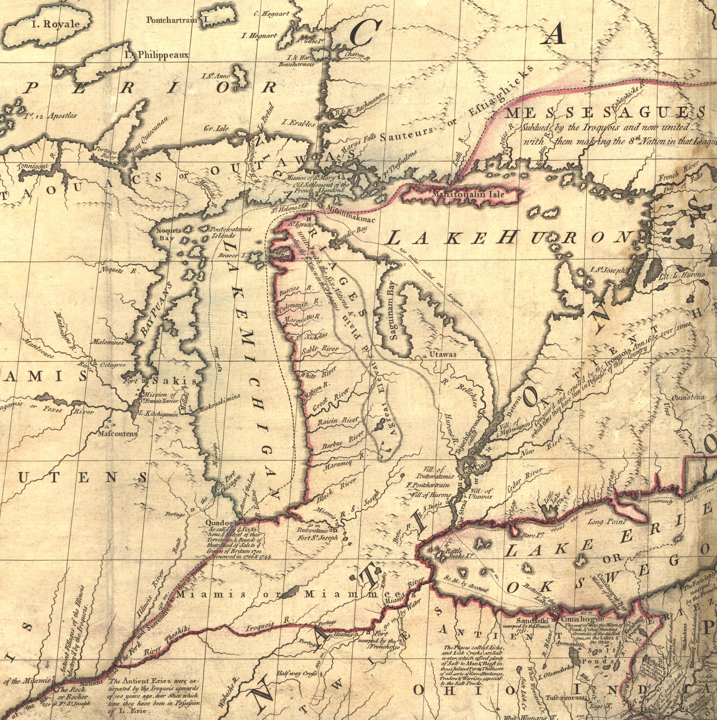
| 解説 | Mitchell Map - A map of the British and French dominions in North America,...; 1757, cropped to Michigan region |
| 日付 | 1755年と1757年の間 |
| 原典 | Library of Congress |
| 作者 | John Mitchell; digital version, Library of Congress, Geography and Map Division. |
| 許可 (ファイルの再利用) |
"The Library of Congress is providing access to these materials for educational and research purposes and is not aware of any U.S. copyright protection" (source: http://memory.loc.gov/cgi-bin/ammemrr.pl?title=Map%20Collections&coll=gmd&div=&agg=g3300&default=ammem&dir=ammem) |
| その他のバージョン | Mitchell Map-06full2.jpg |
ライセンス
|
このファイルは、パブリックドメインの状態にある平面的な美術の著作物を写真術によって忠実に複製したものです。このような複製はアメリカ合衆国においてパブリックドメインの状態にあります。その他の地域では再利用に制限がかかる場合があります。詳しくはReuse of PD-Art photographsをご覧ください。美術の著作物としての原図は、次の理由によりパブリックドメインの状態にあります。
| ||||
元のアップロードログ
元のファイルページはこちら。以下の利用者は全てen.wikipediaに属します。
- 2006-05-03 00:35 Hotstreets 258×277×8 (28294 bytes) Mitchell Map of Michigan region from late 1700s. Public domain, since an image of a public domain image is also public domain. Found on [http://www.usm.maine.edu/~maps/mitchell/full2.jpeg].
ファイルの履歴
過去の版のファイルを表示するには、その版の日時をクリックしてください。
| 日付と時刻 | サムネイル | 寸法 | 利用者 | コメント | |
|---|---|---|---|---|---|
| 現在の版 | 2016年7月4日 (月) 21:53 | | 2,356 × 2,366 (5.97メガバイト) | JasonAQuest | Cropped from file:Mitchell_Map-06full2.jpg |
| 2007年4月11日 (水) 17:01 |  | 258 × 277 (28キロバイト) | Liftarn | {{Information |Description=Mitchell Map of Michigan region from late 1700s. Public domain, since an image of a public domain image is also public domain. Found on [http://www.usm.maine.edu/~maps/mitchell/full2.jpeg]. |Source=Originally from [http://en.wik |
ファイルの使用状況
以下のページがこのファイルを使用しています:
グローバルなファイル使用状況
以下に挙げる他のウィキがこの画像を使っています:
- en.wikipedia.org での使用状況
- it.wikipedia.org での使用状況
- nl.wikipedia.org での使用状況
- pt.wikipedia.org での使用状況
- ru.wikipedia.org での使用状況