
ファイル:Oahu, Hawai'i - NASA Earth Observatory.jpg
Oahu,_Hawai'i_-_NASA_Earth_Observatory.jpg (720 × 480 ピクセル、ファイルサイズ: 132キロバイト、MIME タイプ: image/jpeg)
ウィキメディア・コモンズのファイルページにある説明を、以下に表示します。
|
概要
| 解説 |
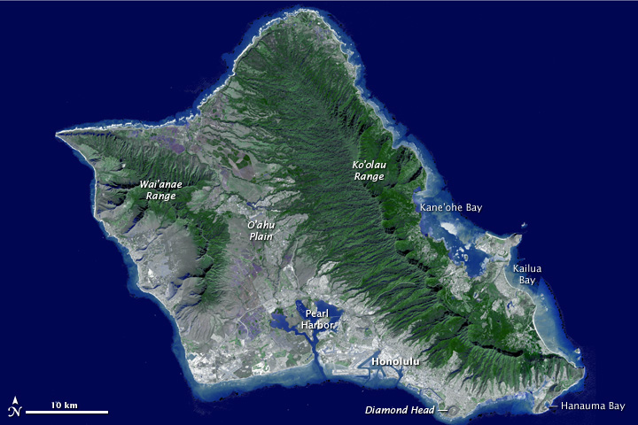
To download the full high res or the video go to: earthobservatory.nasa.gov/IOTD/view.php?id=76244&src=... Need a vacation? Paradise is as close as a mouse click away, thanks to a new fly-around tour of the island of Oahu, Hawaii. The trip comes courtesy of the Advanced Spaceborne Thermal Emission and Reflection Radiometer (ASTER) instrument on NASA’s Terra spacecraft. Sometimes called “The Gathering Place,” Oahu is the third largest of the Hawaiian Islands and home to the state’s capital city, Honolulu. The island has nearly a million residents—about 75 percent of the state’s population.Erosion and volcanism give the island its unique shape. Oahu was created from two separate shield volcanoes—Wai’anae and Ko’olau—that are connected by a central valley, the O’ahu Plain. Your virtual tour begins over Honolulu, then moves northwest over the O'ahu Plain, looking towards the northeast and the Ko’olau mountains. The valley was once largely agricultural, producing pineapple and sugar cane. Reaching the north shore, site of world-famous surfing locations like the Bonzai Pipeline, we turn to the southeast and view the Windward and East Sides of Oahu. Here you’ll find Kane’ohe and Kailua Bays and numerous small offshore islands. Reaching the southeast tip of Oahu, we fly over Hanauma Bay, a protected snorkeling and diving location, and continue past Diamond Head crater, Waikiki Beach and Honolulu. The trip ends with a flyover of Pearl Harbor, home to the largest U.S. Navy fleet in the Pacific. This flyover was created by draping ASTER image data—acquired January 13, 2010—over the new ASTER Version 2 digital elevation data. ASTER carries two telescopes used to record light reflected by the Earth. The telescopes, says ASTER science team leader Mike Abrams, are like two human eyes—seeing the world from two different angles, but combining for a three-dimensional view. Scientists used the differences between the two records to determine the ground elevation. Image courtesy NASA/GSFC/METI/ERSDAC/JAROS, and U.S./Japan ASTER Science Team. Caption adapted from the NASA Photojournal. The Earth Observatory's mission is to share with the public the images, stories, and discoveries about climate and the environment that emerge from NASA research, including its satellite missions, in-the-field research, and climate models. Like us on Facebook Follow us on Twitter |
| 日付 | |
| 原典 | Oahu, Hawai'i |
| 作者 | NASA's Earth Observatory |
| カメラの位置 | | 以下のサービスでこの位置を確認する: オープンストリートマップ |
|---|
ライセンス
- あなたは以下の条件に従う場合に限り、自由に
- 共有 – 本作品を複製、頒布、展示、実演できます。
- 再構成 – 二次的著作物を作成できます。
- あなたの従うべき条件は以下の通りです。
- 表示 – あなたは適切なクレジットを表示し、ライセンスへのリンクを提供し、変更があったらその旨を示さなければなりません。これらは合理的であればどのような方法で行っても構いませんが、許諾者があなたやあなたの利用行為を支持していると示唆するような方法は除きます。
| この画像は当初、NASA Earth Observatory によって Flickr の https://www.flickr.com/photos/68824346@N02/6294469627 に投稿されたものです。2012-07-02、FlickreviewR ボットによってレビューされ、cc-by-2.0 のライセンスで提供されていることが確認されました。 |
ファイルの履歴
過去の版のファイルを表示するには、その版の日時をクリックしてください。
| 日付と時刻 | サムネイル | 寸法 | 利用者 | コメント | |
|---|---|---|---|---|---|
| 現在の版 | 2012年7月2日 (月) 17:21 | | 720 × 480 (132キロバイト) | Dzlinker | == {{int:filedesc}} == {{Information |Description=To download the full high res or the video go to: [http://earthobservatory.nasa.gov/IOTD/view.php?id=76244&src=flickr earthobservatory.nasa.gov/IOTD/view.php?id=76244&src=...] Need a vacation? Paradise... |
ファイルの使用状況
以下のページがこのファイルを使用しています:
グローバルなファイル使用状況
以下に挙げる他のウィキがこの画像を使っています:
- azb.wikipedia.org での使用状況