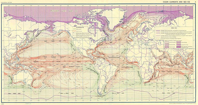
ファイル:Ocean currents 1943.jpg

このプレビューのサイズ: 800 × 426 ピクセル。 その他の解像度: 320 × 170 ピクセル | 640 × 341 ピクセル | 1,024 × 546 ピクセル | 1,280 × 682 ピクセル | 2,639 × 1,406 ピクセル。
元のファイル (2,639 × 1,406 ピクセル、ファイルサイズ: 5.14メガバイト、MIME タイプ: image/jpeg)
ファイルの履歴
過去の版のファイルを表示するには、その版の日時をクリックしてください。
| 日付と時刻 | サムネイル | 寸法 | 利用者 | コメント | |
|---|---|---|---|---|---|
| 現在の版 | 2016年9月6日 (火) 10:58 |  | 2,639 × 1,406 (5.14メガバイト) | Dencey | new |
| 2005年3月31日 (木) 20:20 |  | 2,639 × 1,406 (582キロバイト) | SEWilco | '''Ocean Currents and Sea Ice from Atlas of World Maps.''' United States Army Service Forces, Army Specialized Training Division. Army Service Forces Manual M-101. 1943 {{PD-PCL}} Source: http://www.lib.utexas.edu/maps/world_maps/ocean_currents_ |
ファイルの使用状況
グローバルなファイル使用状況
以下に挙げる他のウィキがこの画像を使っています:
- bn.wikipedia.org での使用状況
- cs.wikipedia.org での使用状況
- de.wikipedia.org での使用状況
- en.wikipedia.org での使用状況
- eo.wikipedia.org での使用状況
- es.wikipedia.org での使用状況
- eu.wikipedia.org での使用状況
- fr.wikipedia.org での使用状況
- fr.wiktionary.org での使用状況
- hu.wikipedia.org での使用状況
- it.wikipedia.org での使用状況
- lt.wikipedia.org での使用状況
- nn.wikipedia.org での使用状況
- oc.wikipedia.org での使用状況
- pt.wiktionary.org での使用状況
- sk.wikipedia.org での使用状況
- sl.wikipedia.org での使用状況
- sv.wikipedia.org での使用状況
- tr.wikipedia.org での使用状況
- vi.wikipedia.org での使用状況
- zh.wikipedia.org での使用状況


