
ファイル:Pentagon road network map 1945.jpg

このプレビューのサイズ: 470 × 599 ピクセル。 その他の解像度: 188 × 240 ピクセル | 377 × 480 ピクセル | 1,020 × 1,300 ピクセル。
元のファイル (1,020 × 1,300 ピクセル、ファイルサイズ: 535キロバイト、MIME タイプ: image/jpeg)
ウィキメディア・コモンズのファイルページにある説明を、以下に表示します。
|
この画像およびメディアは、アメリカ合衆国内務省の実務機関であるアメリカ地質調査所に属する者が職務上作成した著作物のみで構成されているため、アメリカ合衆国国内でパブリックドメインの状態にあります。詳細についてはUSGSの著作物に関する取扱い(英語)をご覧ください。
|
| 記述 |
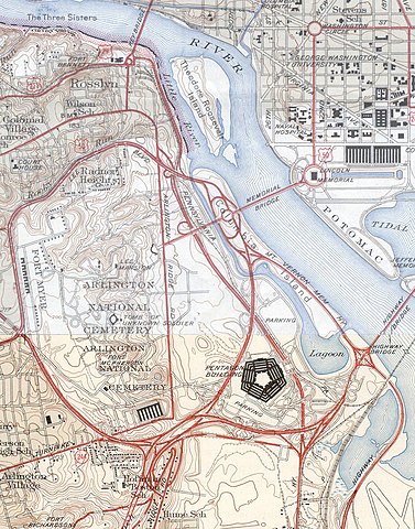
USGS topos covering the area around the Pentagon in Virginia, soon after the road network was built. Note that the Shirley Highway near the south edge of the map was added later, as it opened in 1943. |
|||||||||
| 原典 |
|
|||||||||
| Geotemporal data | ||||||||||
| Bounding box |
|
|||||||||
| Georeferencing | ||||||||||
ファイルの履歴
過去の版のファイルを表示するには、その版の日時をクリックしてください。
| 日付と時刻 | サムネイル | 寸法 | 利用者 | コメント | |
|---|---|---|---|---|---|
| 現在の版 | 2006年1月21日 (土) 19:31 | | 1,020 × 1,300 (535キロバイト) | SPUI~commonswiki | {{PD-USGov-USGS}} USGS topos covering the area around the Pentagon in Virginia, soon after the road network was built. Note that the Shirley Highway near the southwest edge of the map was added later, as it opened in 1943. *North half: [http://historical. |
ファイルの使用状況
以下のページがこのファイルを使用しています:
グローバルなファイル使用状況
以下に挙げる他のウィキがこの画像を使っています:
- ar.wikipedia.org での使用状況
- ast.wikipedia.org での使用状況
- ca.wikipedia.org での使用状況
- da.wikipedia.org での使用状況
- de.wikipedia.org での使用状況
- el.wikipedia.org での使用状況
- en.wikipedia.org での使用状況
- et.wikipedia.org での使用状況
- ga.wikipedia.org での使用状況
- he.wikipedia.org での使用状況
- hr.wikipedia.org での使用状況
- hy.wikipedia.org での使用状況
- it.wikipedia.org での使用状況
- kn.wikipedia.org での使用状況
- pl.wikipedia.org での使用状況
- pnb.wikipedia.org での使用状況
- tr.wikipedia.org での使用状況
- uz.wikipedia.org での使用状況
- www.wikidata.org での使用状況