
ファイル:Possible definitions of the boundary between Europe and Asia.png
元のファイル (729 × 1,129 ピクセル、ファイルサイズ: 207キロバイト、MIME タイプ: image/png)
ウィキメディア・コモンズのファイルページにある説明を、以下に表示します。
|
概要
| 解説 |
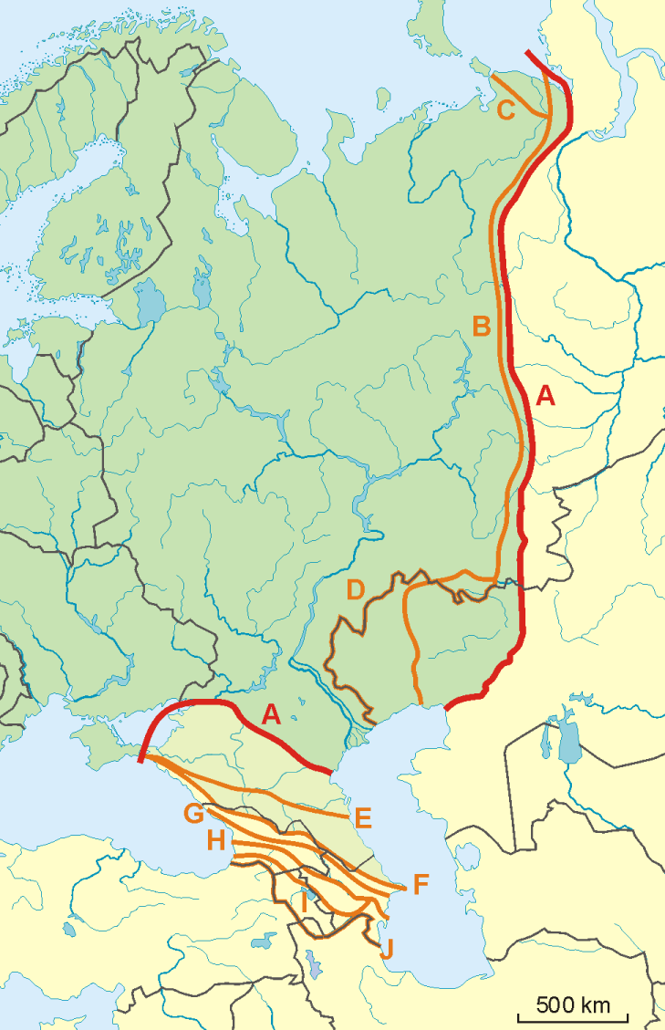
English: A map of possible definitions of the boundary between Asia and Europe.
Note that most of these lines are not referenced to any sources proposing them. The red line marked "A" is apparently the "Strahlenberg" definition commononly taught in Soviet-era Russia. See File:Historical Europe-Asia boundaries 1700 to 1900.png for a map which is actually based on references. The modern mainstream definition used by the UN (see also this) are marked "B" (Urals and Ural River) and "F" (Caucasus watershed). Lines C, D, E, G, H, I and J are currently without reference. Red line - "Strahlenberg" border, allegedly also used by the International Geographical Union [1]
Orange lines - other variants of border:
Polski: Mapa wariantów przebiegów granicy pomiędzy Europą a Azją
linie pomarańczowe - inne warianty przebiegu granicy:
|
| 日付 | 09-04-2008 |
| 原典 | 投稿者自身による著作物 |
| 作者 | Aotearoa |
| その他のバージョン | Image:TransAsia m.png, File:Historical Europe-Asia boundaries 1700 to 1900.png |
ライセンス

|
この文書は、フリーソフトウェア財団発行のGNUフリー文書利用許諾書 (GNU Free Documentation License) 1.2またはそれ以降のバージョンの規約に基づき、複製や再配布、改変が許可されます。不可変更部分、表紙、背表紙はありません。このライセンスの複製は、GNUフリー文書利用許諾書という章に含まれています。 |
- あなたは以下の条件に従う場合に限り、自由に
- 共有 – 本作品を複製、頒布、展示、実演できます。
- 再構成 – 二次的著作物を作成できます。
- あなたの従うべき条件は以下の通りです。
- 表示 – あなたは適切なクレジットを表示し、ライセンスへのリンクを提供し、変更があったらその旨を示さなければなりません。これらは合理的であればどのような方法で行っても構いませんが、許諾者があなたやあなたの利用行為を支持していると示唆するような方法は除きます。
- 継承 – もしあなたがこの作品をリミックスしたり、改変したり、加工した場合には、あなたはあなたの貢献部分を元の作品とこれと同一または互換性があるライセンスの下に頒布しなければなりません。
ファイルの履歴
過去の版のファイルを表示するには、その版の日時をクリックしてください。
| 日付と時刻 | サムネイル | 寸法 | 利用者 | コメント | |
|---|---|---|---|---|---|
| 現在の版 | 2022年11月14日 (月) 08:34 | | 729 × 1,129 (207キロバイト) | Рагин1987 | Dull shade of green up to the "F" line |
| 2022年2月19日 (土) 13:12 |  | 729 × 1,129 (205キロバイト) | Lojwe | Frame removed | |
| 2010年10月1日 (金) 20:29 |  | 735 × 1,134 (156キロバイト) | Bogomolov.PL | Reverted to version as of 08:57, 9 April 2008 | |
| 2010年10月1日 (金) 19:44 |  | 735 × 1,134 (137キロバイト) | Zé Carioca~commonswiki | Trying to fix the error we are facing on the articles. | |
| 2010年10月1日 (金) 15:56 |  | 735 × 1,134 (137キロバイト) | Gvogas | Inclusion of the Miles Clark route line. (sorry for the tries, my internet gave problems). | |
| 2010年10月1日 (金) 15:55 |  | 735 × 1,134 (137キロバイト) | Gvogas | Reverted to version as of 15:52, 1 October 2010 | |
| 2010年10月1日 (金) 15:54 |  | 735 × 1,134 (137キロバイト) | Gvogas | (Inclusion of the Miles Clark route line.) | |
| 2010年10月1日 (金) 15:52 |  | 735 × 1,134 (137キロバイト) | Gvogas | Inclusion of the Miles Clark route line. | |
| 2008年4月9日 (水) 08:57 |  | 735 × 1,134 (156キロバイト) | Aotearoa | {{Information |Description=Map of Europe (green) - Asia (yellow) border. Red line (A) - border accoring to International Geographical Union and most European geographers, orange lines - other variants of border. |Source=własna praca |Date=09-04-2008 | |
ファイルの使用状況
以下のページがこのファイルを使用しています:
グローバルなファイル使用状況
以下に挙げる他のウィキがこの画像を使っています:
- am.wikipedia.org での使用状況
- ar.wikipedia.org での使用状況
- arz.wikipedia.org での使用状況
- az.wikipedia.org での使用状況
- ba.wikipedia.org での使用状況
- be.wikipedia.org での使用状況
- bn.wikipedia.org での使用状況
- ca.wikipedia.org での使用状況
- ce.wikipedia.org での使用状況
- cs.wikipedia.org での使用状況
- de.wikipedia.org での使用状況
- Eurasien
- Portal:Mauern und Grenzen
- Liste interkontinentaler Staaten
- Wikipedia Diskussion:WikiProjekt Geographie/Archiv/2013-1
- Wikipedia:Löschkandidaten/28. Februar 2016
- Wikipedia Diskussion:WikiProjekt Kategorien/Archiv/2016-II
- Wikipedia Diskussion:Kurier/Archiv/2017/10
- Vorlage Diskussion:Navigationsleiste Kraftwerke
- Wikipedia Diskussion:Kurier/Archiv/2022/08
- en.wikipedia.org での使用状況
- et.wikipedia.org での使用状況
- hr.wikipedia.org での使用状況
- Kategorija:Arktičkooceanski slijev (Europa)
- Kategorija:Arktičkooceanski slijev (Azija)
- Kategorija:Mora Arktičkog oceana
- Kategorija:Reljefni oblici u Arktičkom oceanu
- Kategorija:Mora Arktičkog oceana (Azija)
- Kategorija:Mora Arktičkog oceana (Europa)
- Kategorija:Reljefni oblici u Arktičkom oceanu (Azija)
- Kategorija:Tjesnaci Arktičkog oceana (Europa)
- Kategorija:Vodene mase Arktičkog oceana (Europa)
- Kategorija:Reljefni oblici u Arktičkom oceanu (Europa)
- Kategorija:Tjesnaci Arktičkog oceana (Azija)
- Kategorija:Vodene mase Arktičkog oceana (Azija)
- Kategorija:Karsko more
- Predložak:Granica Europe i Azije
- Kategorija:Zaljevi Arktičkog oceana (Azija)
- Kategorija:Zaljevi Arktičkog oceana (Europa)
- Kategorija:Estuariji Arktičkog oceana (Azija)
- Kategorija:Estuariji Tihog oceana (Azija)
- hu.wikipedia.org での使用状況
- hy.wikipedia.org での使用状況
このファイルのグローバル使用状況を表示する。