
ファイル:Stalingrad - Preparations for Operation Uranus.png
このプレビューのサイズ: 800 × 492 ピクセル。 その他の解像度: 320 × 197 ピクセル | 640 × 394 ピクセル | 1,024 × 630 ピクセル | 1,280 × 788 ピクセル | 2,560 × 1,576 ピクセル | 4,321 × 2,660 ピクセル。
元のファイル (4,321 × 2,660 ピクセル、ファイルサイズ: 2.83メガバイト、MIME タイプ: image/png)
ウィキメディア・コモンズのファイルページにある説明を、以下に表示します。
|

|
この地図画像は、ベクターイメージである SVG ファイルとして再作成されるべきです。これにはいくつかの利点があります。詳しくはCommons:Media for cleanupを参照してください。この画像の SVG 形式がすでに利用可能である場合は、アップロードしてください。アップロード後、この画像にあるこのテンプレートを{{Vector version available|新しい画像ファイル名.svg}}テンプレートで置き換えてください。
|
概要
| 解説 |
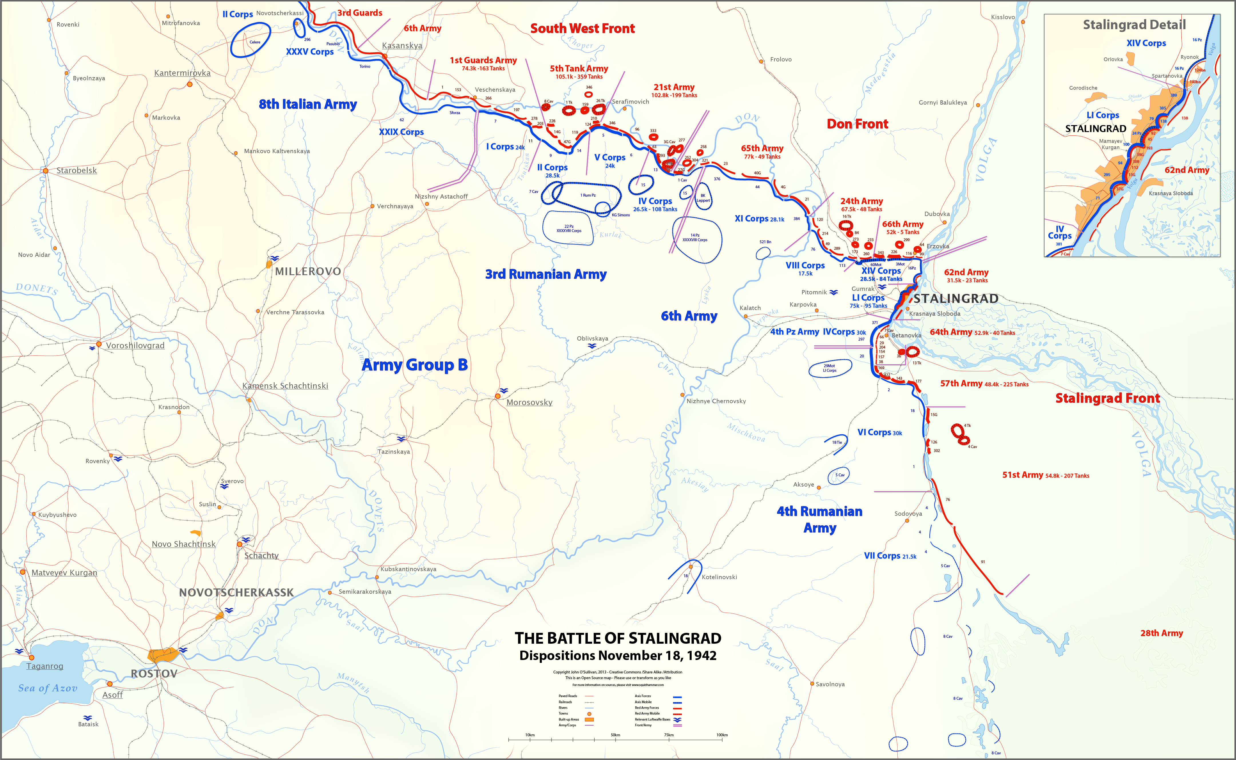
English: This map shows unit locations and relative strengths for Axis and Soviet Armies on Nov 18, 1942, during the Battle of Stalingrad.
On November 19, the Soviets launched Operation Uranus, an offensive designed to isolate and destroy the German 6th Army at Stalingrad. |
| 日付 | |
| 原典 | 投稿者自身による著作物 |
| 作者 | Josullivan.59 |
| その他のバージョン |
 |
Sources:
Books and Articles
| Author | Title | Notes |
| Alexei V. Isaev | Stalingrad: The Volga No Land For Us | Soviet forces and tanks |
| Antony Beevor | Stalingrad-The-Fateful-Siege-1942-1943 | Most widely cited Order of Battle |
| Wikipedia | Red Army Order of Battle Stalingrad | Useful |
| Wikipedia | Axis order of battle at the Battle of Stalingrad | Not particularly useful |
| Staldata | Staldata | Axis and Soviet Orders of Battle & force strength |
| Wolf Höpper | Against the Flood - Operation Uranus (I) | German tank numbers |
| Joel S. A. Hayward | Stopped At Stalingrad: The Luftwaffe And Hitler's Defeat In The East 1942-1943 | Bases used for Airlift |
| Akhil Kadidal | Stalingrad Pocket | Really good maps and annotated photographs |
Maps
| Title | Source | Notes |
| OKH Situation Map Nov 18 42 | WW2 Photos Maps | Axis forces locations Fantastic Site! |
| OKH Situation Map Nov 18 42 2 | WW2 Photos Maps | Axis forces locations Fantastic Site! |
| S4231 Summary of combat operations in Stalingrad | Armchair General/RIIAWW2 | Red Army locations Excellent map |
| S4239 Operations in Stalingrad area | RIIAWW2 Armchair General/RIIAWW2 | Red Army locations |
| S4251 Combat operations of the South-Western, Don and Stalingrad Fronts | Armchair General/RIIAWW2 | Red Army locations |
Notes:
- My Order of Battle is here.
- There are more units listed in the Order of Battle than appear on the map. I didn't place any unit on the map unless I could find it in one of the source maps.
- In conflicts between locations on the OKH map and the Soviet maps, I used the Soviet map. The Germans had not picked up the Uranus build-up, so the Soviets had much better intelligence at this time.
- I could find no information on the strength of the 8th Italian Army, or Soviet 6th and 3rd Guards Armies.
- Unit lines are thicker or thinner based on strength and density. These are characterizations, not precise measurements.
- Unit strengths are shown in the layers in the SVG version of the map. These are based on the Order of Battle spreadsheet linked above. The spreadsheet includes notes on the units shown on the map.
- The base map is derived from the OKH maps. I do not know the map projection.
- Please feel free to comment on any inaccuracies! You can help to make the map better. I'm particularly interested in proper place-names.
- あなたは以下の条件に従う場合に限り、自由に
- 共有 – 本作品を複製、頒布、展示、実演できます。
- 再構成 – 二次的著作物を作成できます。
- あなたの従うべき条件は以下の通りです。
- 表示 – あなたは適切なクレジットを表示し、ライセンスへのリンクを提供し、変更があったらその旨を示さなければなりません。これらは合理的であればどのような方法で行っても構いませんが、許諾者があなたやあなたの利用行為を支持していると示唆するような方法は除きます。
- 継承 – もしあなたがこの作品をリミックスしたり、改変したり、加工した場合には、あなたはあなたの貢献部分を元の作品とこれと同一または互換性があるライセンスの下に頒布しなければなりません。
ライセンス
この作品の著作権者である私は、この作品を以下のライセンスで提供します。
このファイルはクリエイティブ・コモンズ 表示-継承 3.0 非移植ライセンスのもとに利用を許諾されています。
ファイルの履歴
過去の版のファイルを表示するには、その版の日時をクリックしてください。
| 日付と時刻 | サムネイル | 寸法 | 利用者 | コメント | |
|---|---|---|---|---|---|
| 現在の版 | 2013年3月12日 (火) 18:27 | | 4,321 × 2,660 (2.83メガバイト) | Josullivan.59 | Fixed the licensing information on the map. |
| 2013年3月12日 (火) 18:13 |  | 4,322 × 2,660 (3.89メガバイト) | Josullivan.59 | User created page with UploadWizard |
ファイルの使用状況
以下の 2 ページがこのファイルを使用しています:
グローバルなファイル使用状況
以下に挙げる他のウィキがこの画像を使っています:
- de.wikipedia.org での使用状況
- en.wikipedia.org での使用状況
- es.wikipedia.org での使用状況
- fi.wikipedia.org での使用状況
- fr.wikipedia.org での使用状況
- no.wikipedia.org での使用状況
- pt.wikipedia.org での使用状況
- uk.wikipedia.org での使用状況