
ファイル:Trans Alaska Pipeline Denali fault shift.jpg
このプレビューのサイズ: 800 × 600 ピクセル。 その他の解像度: 320 × 240 ピクセル | 640 × 480 ピクセル | 1,024 × 768 ピクセル | 1,280 × 960 ピクセル | 2,560 × 1,920 ピクセル。
元のファイル (2,560 × 1,920 ピクセル、ファイルサイズ: 570キロバイト、MIME タイプ: image/jpeg)
ウィキメディア・コモンズのファイルページにある説明を、以下に表示します。
|
概要
| 解説 |
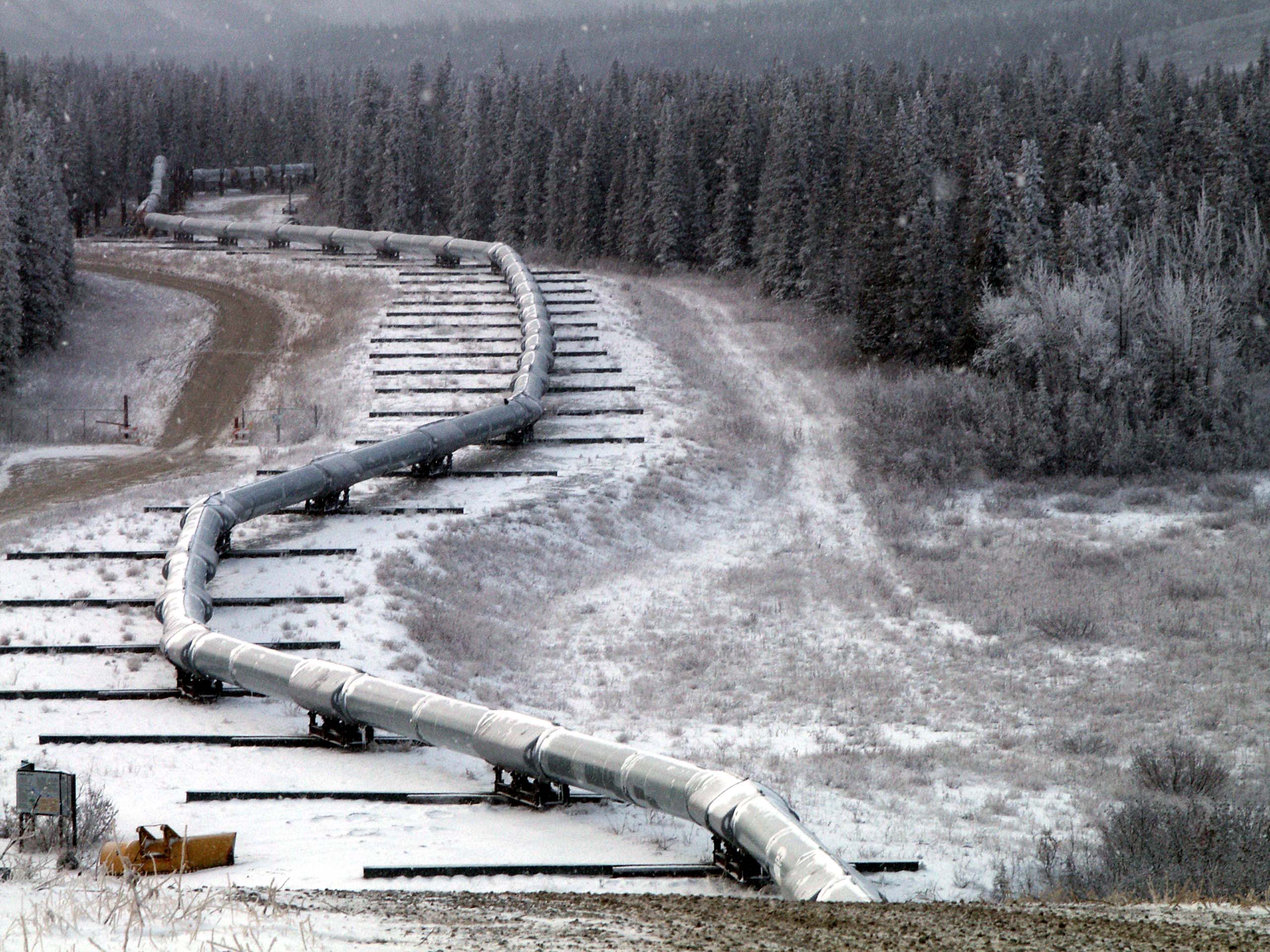
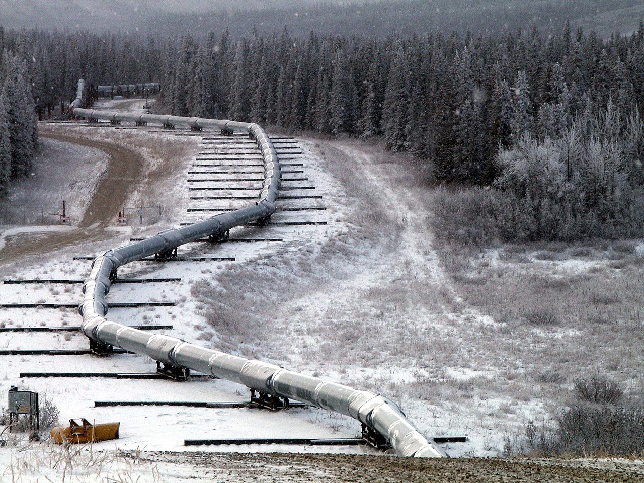
English: Trace of the Denali Fault after the 7.9 magnitude earthquake of 3 November 2002, Alaska, USA. View south along the Trans-Alaska Pipeline System in the zone where it was engineered to cross the fault (the pipeline rests on sliders rather than rigid pillar supports). The fault trace passes beneath the pipeline between the 2nd and 3rd slider supports at the far end of the zone. A large arc in the pipe can be seen in the pipe on the right, due to shortening of the zigzag-shaped pipeline trace within the fault zone. It was snowing when the photo was taken. |
| 日付 | |
| 原典 | Denali Fault Earthquake Photos 07 Nov 2002 (Direct link) |
| 作者 | U.S. Geological Survey employee |
| カメラの位置 | | 以下のサービスでこの位置を確認する: オープンストリートマップ |
|---|
ライセンス
この画像およびメディアは、アメリカ合衆国内務省の実務機関であるアメリカ地質調査所に属する者が職務上作成した著作物のみで構成されているため、アメリカ合衆国国内でパブリックドメインの状態にあります。詳細についてはUSGSの著作物に関する取扱い(英語)をご覧ください。
|
ファイルの履歴
過去の版のファイルを表示するには、その版の日時をクリックしてください。
| 日付と時刻 | サムネイル | 寸法 | 利用者 | コメント | |
|---|---|---|---|---|---|
| 現在の版 | 2007年8月4日 (土) 05:58 | | 2,560 × 1,920 (570キロバイト) | Whhalbert | |
| 2007年8月4日 (土) 05:55 |  | 800 × 600 (137キロバイト) | Whhalbert | == Summary == Alaska Denali Fault after November 3rd 7.9 magnitude earthquake: November 7, 2002. View south along the Trans-Alaska Pipeline System in the zone where it was engineered for the Denali fault. The fault trace passes beneath th |
ファイルの使用状況
以下のページがこのファイルを使用しています:
グローバルなファイル使用状況
以下に挙げる他のウィキがこの画像を使っています:
- de.wikipedia.org での使用状況
- en.wikipedia.org での使用状況
- en.wikibooks.org での使用状況
- es.wikipedia.org での使用状況
- fa.wikipedia.org での使用状況
- fi.wikipedia.org での使用状況
- fr.wikipedia.org での使用状況
- nl.wikipedia.org での使用状況
- pl.wikipedia.org での使用状況
- ru.wikipedia.org での使用状況
- th.wikipedia.org での使用状況
- tr.wikipedia.org での使用状況
- zh.wikipedia.org での使用状況