
ファイル:Zhenghe-sailing-chart.gif
このプレビューのサイズ: 800 × 570 ピクセル。 その他の解像度: 320 × 228 ピクセル | 640 × 456 ピクセル | 1,024 × 730 ピクセル | 1,280 × 912 ピクセル | 1,454 × 1,036 ピクセル。
元のファイル (1,454 × 1,036 ピクセル、ファイルサイズ: 174キロバイト、MIME タイプ: image/gif)
ウィキメディア・コモンズのファイルページにある説明を、以下に表示します。
|
概要
| 解説 |
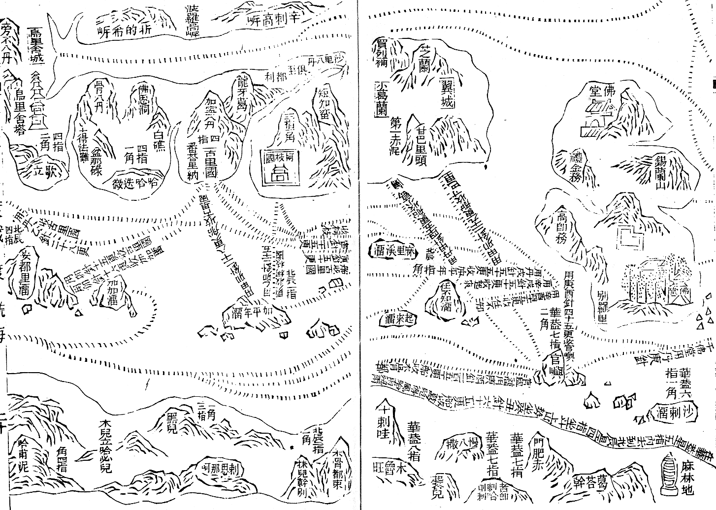
English: Part of the Wu bei zhi chart of Zheng He showing the west coast of India along the top, Ceylon top right and Africa along the bottom. The sailing directions are shown using zhen lu compass directions.
Русский: Фрагмент навигационной карты ("карта Мао Куня") из энциклопедии "Убэй чжи", показывающий бассейн Аравийского моря.
Север слева, восток вверху. В правом верхнем углу - остров Цейлон (錫蘭山,Силаньшань - остров/гора Силань); в правом нижнем углу - порт Малинди (麻林地, Малиньди) |
| 日付 | Early 15th century map. Published in Wubei Zhi in 1628. |
| 原典 | Wubei Zhi |
| 作者 |
ライセンス
|
この著作物は、著作権の保護期間が著作者の死後100年以下である国・地域においてパブリックドメインの状態にあります。 | |
| このファイルは著作権法の既知の制約(隣接権や関連する権利を含む)から自由であると特定されています。 | |
元のアップロードログ
元のファイルページはこちら。以下の利用者は全てen.wikipediaに属します。
- 2008-07-04 22:54 Chris55 1454×1036× (177834 bytes) Part of the Wu bei zhi chart of Zheng He showing the west coast of India along the top, Ceylon top right and Africa along the bottom. The sailing directions are shown using zhen lu compass directions.
ファイルの履歴
過去の版のファイルを表示するには、その版の日時をクリックしてください。
| 日付と時刻 | サムネイル | 寸法 | 利用者 | コメント | |
|---|---|---|---|---|---|
| 現在の版 | 2009年9月1日 (火) 04:30 | | 1,454 × 1,036 (174キロバイト) | Rockfang | {{Information |Description={{en|Part of the Wu bei zhi chart of Zheng He showing the west coast of India along the top, Ceylon top right and Africa along the bottom. The sailing directions are shown using zhen lu compass directions.}} |Source=Transferred |
ファイルの使用状況
以下のページがこのファイルを使用しています:
グローバルなファイル使用状況
以下に挙げる他のウィキがこの画像を使っています:
- ast.wikipedia.org での使用状況
- azb.wikipedia.org での使用状況
- en.wikipedia.org での使用状況
- en.wikiquote.org での使用状況
- es.wikipedia.org での使用状況
- ro.wikipedia.org での使用状況
- ru.wikipedia.org での使用状況
- sl.wikipedia.org での使用状況
- ta.wikipedia.org での使用状況
- uk.wikipedia.org での使用状況
- vi.wikipedia.org での使用状況
- vi.wikibooks.org での使用状況