
ファイル:Zhou occidentaux etats.svg

この SVG ファイルのこの PNG プレビューのサイズ: 568 × 384 ピクセル. その他の解像度: 320 × 216 ピクセル | 640 × 433 ピクセル | 1,024 × 692 ピクセル | 1,280 × 865 ピクセル | 2,560 × 1,731 ピクセル。
元のファイル (SVG ファイル、568 × 384 ピクセル、ファイルサイズ: 712キロバイト)
ウィキメディア・コモンズのファイルページにある説明を、以下に表示します。
|
概要
| 解説 |
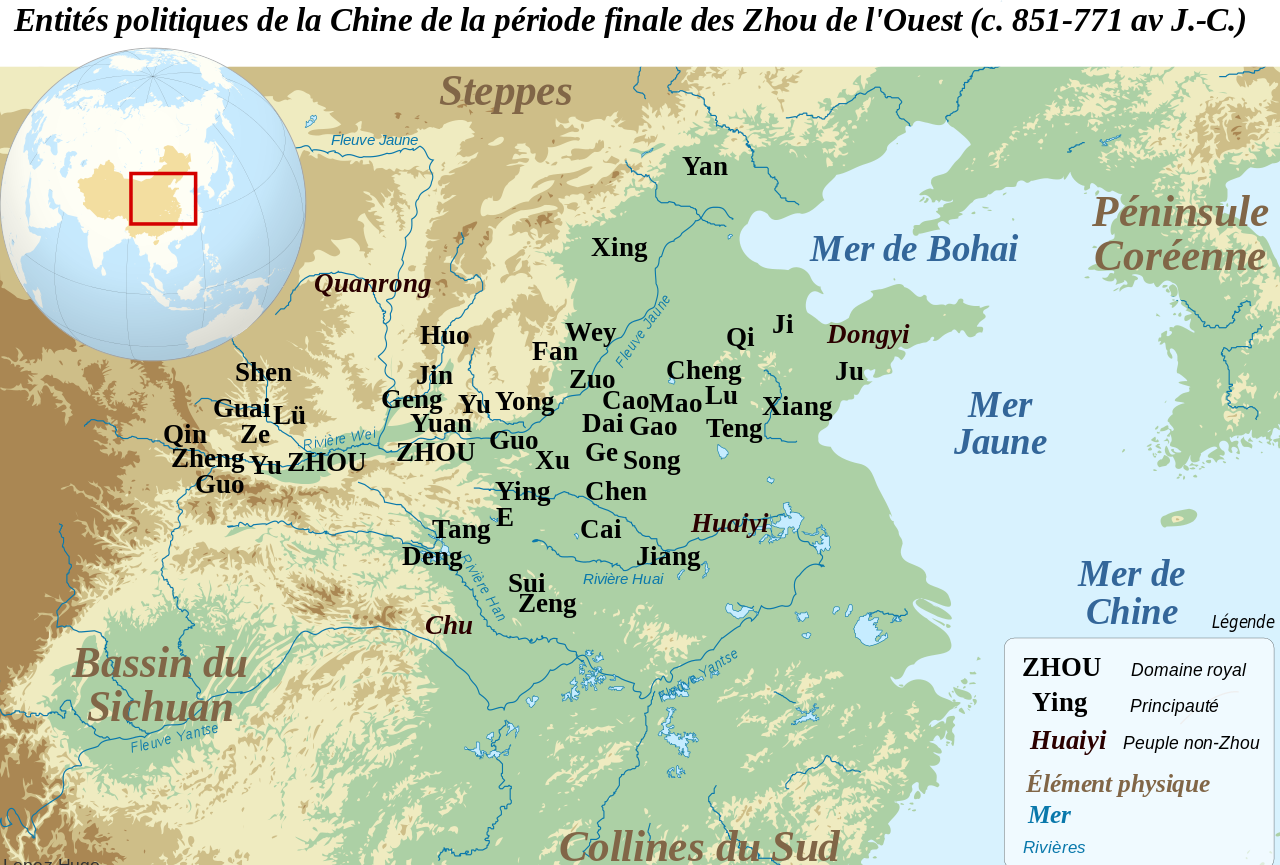
Français : Carte de localisation des principales entités politiques de la Chine du Nord durant la période finale des Zhou de l'Ouest (c. 851-771 av. J.-C. Les localisations des principautés sont souvent approximatives, et reposent sur les propositions et cartes de F. Li, Landscape and Power in Early China, The Crisis and Fall of the Western Zhou 1045-771 BC, New York, 2006. Les principautés de l'Ouest (Zheng, Guo, Shen, Lü et Qin) sont localisées avant leurs migrations vers l'est. English: Location map of the main political actors of the Late Western Zhou Period (c. 851-771 BC). Many of the locations given are only approximate, and based on the conclusions and maps of F. Li, Landscape and Power in Early China, The Crisis and Fall of the Western Zhou 1045-771 BC, New York, 2006. Western states such as Zheng, Guo, Shen, Lü and Qin are located before their eastward migrations. |
| 日付 | |
| 原典 |
このファイルの派生元: Chinese plain 5c. BC-fr.svg: |
| 作者 |
|
この画像には画像編集が施されています。原本に対して次のデジタル的な変更が行われました。
|
ライセンス
この作品の著作権者である私は、この作品を以下のライセンスで提供します。
このファイルはクリエイティブ・コモンズ 表示-継承 3.0 非移植ライセンスのもとに利用を許諾されています。
- あなたは以下の条件に従う場合に限り、自由に
- 共有 – 本作品を複製、頒布、展示、実演できます。
- 再構成 – 二次的著作物を作成できます。
- あなたの従うべき条件は以下の通りです。
- 表示 – あなたは適切なクレジットを表示し、ライセンスへのリンクを提供し、変更があったらその旨を示さなければなりません。これらは合理的であればどのような方法で行っても構いませんが、許諾者があなたやあなたの利用行為を支持していると示唆するような方法は除きます。
- 継承 – もしあなたがこの作品をリミックスしたり、改変したり、加工した場合には、あなたはあなたの貢献部分を元の作品とこれと同一または互換性があるライセンスの下に頒布しなければなりません。
元のアップロードログ
This image is a derivative work of the following images:
- File:Chinese_plain_5c._BC-fr.svg licensed with Cc-by-sa-3.0
Uploaded with derivativeFX
ファイルの履歴
過去の版のファイルを表示するには、その版の日時をクリックしてください。
| 日付と時刻 | サムネイル | 寸法 | 利用者 | コメント | |
|---|---|---|---|---|---|
| 現在の版 | 2012年8月6日 (月) 15:52 | | 568 × 384 (712キロバイト) | Zunkir | Nouvel essai. |
| 2012年8月6日 (月) 15:50 |  | 568 × 384 (712キロバイト) | Zunkir | Reverted to version as of 15:46, 6 August 2012 | |
| 2012年8月6日 (月) 15:49 |  | 568 × 384 (712キロバイト) | Zunkir | Reverted to version as of 09:20, 6 August 2012 | |
| 2012年8月6日 (月) 15:46 |  | 568 × 384 (712キロバイト) | Zunkir | Nouvel essai. | |
| 2012年8月6日 (月) 09:20 |  | 568 × 384 (712キロバイト) | Zunkir | Modif localisation des Quanrong. | |
| 2012年4月30日 (月) 09:56 |  | 568 × 384 (712キロバイト) | Zunkir | == {{int:filedesc}} == {{Information |Description={{fr|1=Carte de localisation des principales entités politiques de la Chine du Nord durant la période finale des Zhou de l'Ouest (c. 851-771 av. J.-C. Les localisations des principautés sont souvent ... |
ファイルの使用状況
以下のページがこのファイルを使用しています:
グローバルなファイル使用状況
以下に挙げる他のウィキがこの画像を使っています:
- en.wikipedia.org での使用状況
- fr.wikipedia.org での使用状況
- it.wikipedia.org での使用状況
- pl.wikipedia.org での使用状況
- ru.wikipedia.org での使用状況
- sv.wikipedia.org での使用状況