
ヘブロン/アル=ハリール旧市街
| |||
|---|---|---|---|
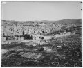
 ヘブロン/アル=ハリールの旧市街。地元の石灰石を使用した建築群からなる街並みと、その向こうに見えるイブラヒーム・モスク(ミナレットがある部分)/族長たちの墓。 | |||
| 英名 | Hebron/Al-Khalil Old Town | ||
| 仏名 | Vieille ville d’Hébron/Al-Khalil | ||
| 面積 |
資産 20.6ヘクタール 緩衝地帯 152.2ヘクタール | ||
| 登録区分 | 文化遺産 | ||
| 登録基準 | (2), (4), (6) | ||
| 登録年 | 2017年(第41回世界遺産委員会) | ||
| 危機遺産 | 2017年- | ||
| 備考 |
緊急的登録推薦にて登録。 | ||
| 公式サイト | 世界遺産センター(英語) | ||
| 地図 | |||
 | |||
| 使用方法・表示 | |||

座標: 北緯31度31分31秒 東経35度06分30秒 / 北緯31.52528度 東経35.10833度
ヘブロン/アル=ハリール旧市街 (ヘブロン/アル=ハリールきゅうしがい、アラビア語: البلدة القديمة في الخليل、アル=ハリールの旧市街、ヘブライ語: עיר העתיקה של חברון、ヘブロンの旧市街) は、パレスチナのヨルダン川西岸地区にあるアル=ハリール(ヘブロン)の歴史的中心地である。考古学者たちは、古代のヘブロンは、最初は別の場所である、今日の旧市街から西に約200メートル離れたテル・ルメイダから始まったと考えており、もともとはカナン人の都市であったと考えられている。現在の旧市街は、ギリシャまたはローマ時代(紀元前3世紀から紀元前1世紀頃)に定住がなされ[1][2]、アッバース朝(紀元750年頃開始)の時代にヘブロン地域全体の中心地となった。
2017年にパレスチナ国で3番目の世界遺産に登録された[3][4]。この旧市街は、イスラエルの軍事占領下にあり、国際記念物遺跡会議 (ICOMOS) の調査員が候補地を訪れる許可が実効支配しているイスラエルから降りなかったため現地調査が出来ず[5]、ICOMOSは通例の勧告を出さず保留した[6]。ICOMOSの勧告保留は世界遺産条約史上初めてのことだった[7]。しかし、緊急的登録推薦という例外的な方法で推薦及び世界遺産委員会会議での審議が行われ、最後は秘密投票によって[8]文化遺産として登録が可決されると同時に危機遺産入りをした[9][10]。
旧市街は、聖書の族長(父祖)と母祖の伝統的な埋葬地であり、アブラハムの宗教のユダヤ教徒、キリスト教徒、モスリムによって崇敬されている聖所および巡礼地である「族長たちの墓/イブラヒーム・モスク」を取り囲むように建設されている[11]。また同市街は、ヘブロンのイスラエルとパレスチナの紛争においてセンシティブな場所である[12]。
ランドマーク[編集]
礼拝所[編集]
- 族長たちの墓/イブラヒーム・モスク、アル=ジャウリ・モスク や、ウスマーン・イブン・アッファーン・モスク 、及びイブラヒーム・ホスピスを含む。
- シャイフ・アリ・アル・バッカ・モスク
- カザジン・モスク (Qazzazin Mosque)
- アブラハム アヴィヌ・シナゴーク
博物館[編集]
地区と街区[編集]
19世紀末、旧市街は9つの街区(ハラ)に分かれていたと記録されている[13]。
- シャイフ・アリー・バッカ街区、Sheikh 'Aly Bakka quarter、アラビア語: حارة الشيخ علي البكا;
- ザーウィヤ街区、Zawiya quarter (Haret ez Zawieh)、アラビア語: حارة باب الزاوية;
- ガラス職人街区、Glassmakers quarter (Haret Kezazin)、アラビア語: حارة القزازين ( ヘブロン・ガラスを参照);
- イル・アカーバ街区、el Akkabeh、(上り坂の街区)、アラビア語: حارة العقّابة;
- ハラム街区、Haram quarter、アラビア語: حارة الحرم;
- ムヘイシン街区、Muheisin quarter (一家の名前);
- コットン街区、Cotton quarter (Haret Kotton)、アラビア語: حارة قيطون;
- 東部街区、The eastern quarter (Haret Mesherky)、アラビア語: حارة المشارقة;
- 新街区、The new quarter、アラビア語: حارة الجديد;
旧市街の周縁部には、3つの小さなユダヤ人入植地、ベイト・ハダサ、ベイト・ロマーノ、アブラハム・アヴィヌ[注釈 1]があり、これらは「ゆるやかに隣接したユダヤ人地区」[15]または「ユダヤ人街区」[16]を形成していると描写されている。 19世紀後半のユダヤ人地域はガラス職人街区にあった[17][18]。
ヘブロンの分割[編集]
1995年のオスロ合意とそれに続く1997年のヘブロン合意により、パレスチナの都市はパレスチナ自治政府の専属管轄下に置かれたが、ヘブロンは例外で[19]2つの区域に分割され、H-1と呼ばれる区域はパレスチナ自治政府の管轄となり、ヘブロン旧市街を含むH2と呼ばれる区域は依然としてイスラエルの軍事支配下に置かれた[20][21]。H-2には、約3万人のパレスチナ人住民と、旧ユダヤ人地区に移り住んできた約800人のユダヤ人入植者がおり、ユダヤ人住民を「保護」するため、イスラエル国防軍の1個旅団全体が配置されている[22][23]。パレスチナ人は、住民であるか[注釈 2]、住民を訪れる以外は、イスラエル国防軍の特別な許可なしには、入植者が住む地域に近づくことができない[25]。ユダヤ人の入植は国際社会の広きに渡って違法であると考えられているが、イスラエル政府はこれに異議を唱えている[26][注釈 3]
イスラエルによる人種/民族隔離[編集]
.jpg)
旧市街が位置するH-2のパレスチナ人人口は、夜間外出禁止令の延長、移動への厳しい制限[30]、入植地域付近のパレスチナ人の商業活動の閉鎖などといったイスラエルの治安対策の影響、及び入植者の嫌がらせにより、大幅に減少している[31][32][33][34]。パレスチナ人は、主要な商業大通りであるアッシュハダ通りの使用を禁じられており、その結果、地元では「アパルトヘイト通り」と呼ばれている[35][36]。

パレスチナ人の通行が閉鎖された道沿いに、パレスチナ人住宅の出入り口や窓があった場合、それらはイスラエル軍によって塞がれ、住民の移動の自由などの人権が損なわれる事はもちろんのこと、歴史的景観の完全性と真正性が損なわれると文化財保全・保存の観点からも問題視された[24][37][38]。
世界遺産[編集]

世界遺産登録の対象はマムルーク朝時代にヘブロン/アル=ハリール旧市街を形作った地元石灰岩を使用した建築群と、旧市街の中心に位置するユダヤ教・キリスト教・イスラム教の始祖(族長)アブラハム/イブラヒームとその家族の墓を保護するために紀元1世紀に建てられた敷地内にある、イブラヒーム・モスク/族長たちの墓である[3]。
普遍的な価値があり、他の既存世界遺産に見当たらない唯一無二の独自性は、イブラヒーム・モスク/族長たちの墓が、一神教の3大宗教であるユダヤ教、キリスト教、イスラム教にとって宗教的・精神的に同等の重要性を誇り、かつそれらの信者たちが「一緒に」[注釈 4]祈りを捧げることが可能であることだと世界遺産遺産委員会であげられた[40]。
ギャラリー[編集]
-
 1839年の旅行記『聖地、シリア、エドム、アラビア、エジプト、およびヌビア 』より。
 -
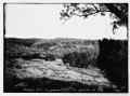
 1910年頃
 -
 タウンセンド・マックン(1899年)
 -
 20世紀初期。
 -
 1910年の旧市街。
 -
 旧市街内を隔てる分離壁。
 -
![イスラエル人入植者がパレスチナ人居住地に落とすゴミを防ぐために旧市街に設置されたネット[41]。アシッドが上層階から注がれる場所は金属の覆いも設置される[24]。](//upload.wikimedia.org/wikipedia/commons/thumb/b/b5/HebronOldCityTrash.jpg/80px-HebronOldCityTrash.jpg)
-


_p039_HEBRON.jpg)


![イスラエル人入植者がパレスチナ人居住地に落とすゴミを防ぐために旧市街に設置されたネット[41]。アシッドが上層階から注がれる場所は金属の覆いも設置される[24]。](/wiki/%E3%83%95%E3%82%A1%E3%82%A4%E3%83%AB:HebronOldCityTrash.jpg)
_Innen_Minbar_2.JPG)
関連項目[編集]
- パレスチナの観光
- 世界遺産の一覧 (危機遺産リスト)
- パレスチナの世界遺産
- ヘブロンのイスラエルとパレスチナの紛争
- 被占領パレスチナ決議(ユネスコ執行理事会のDocument 200 EX/25)
- ハラム・アッシャリーフ/神殿の丘
- サムエルの墓
脚注[編集]
注釈[編集]
- ^ このうち、世界遺産の資産内に位置するのは、ベイト・ロマーノ、アブラハム・アヴィヌの2つの入植地。ベイト・ハダサは緩衝地帯に位置する[14]。
- ^ 同じ複数階の建物のうち、上層階にユダヤ人入植者が住み、下層階にパレスチナ人が居住しており、入り口は別々に設けられている[24]。
- ^ 2022年12月、国際連合総会は、国際司法裁判所 (ICJ) にイスラエルのパレスチナ領域占領の違法性について勧告的意見を求める決議を採択し、2024年2月19日に審理が始まった[27][28]。
- ^ 1994年以降は、同一建物内部が2空間へ仕切られ、入り口も別々に設けられており、ユダヤ教信者とモスリムはそれぞれの空間で祈りを捧げる。年に各10日間、それぞれの宗教の特定祭祀期間中は、片方の信者たちは独占的に両方の空間にアクセスすることが許されているが[39]、同じ空間内でそれぞれの宗教の信者たちが交ざり合って祈りを捧げる訳ではなく、ここでの「一緒に (together)」は「同時に」という意味に近い。
出典[編集]
- ^ Jericke 2003, p. 17: "Spätestens in römischer Zeit ist die Ansiedlung im Tal beim heutigen Stadtzentrum zu finden Zwischen beiden Fundstellen, am Ostfuß des Gebel erRuméde, liegt die für die Wasserversorgung der Stadt wichtige Quelle Ain el-Guděde"
- ^ Achim Lichtenberger, Juden, Idumäer und „Heiden“. Die herodianischen Bauten in Hebron und Mamre, in: L.- M. Günther (ed.), Herodes und Rom (Stuttgart 2007), p.59: "Die hellenistisch-römische Stadt lag im Tal dazwischen"
- ^ a b “Hebron/Al-Khalil Old Town” (英語). UNESCO 世界遺産センター. 2022年12月23日閲覧。
- ^ “ユネスコ、ヘブロン旧市街を危機遺産に イスラエル猛反発”. www.afpbb.com (2017年7月8日). 2024年4月23日閲覧。
- ^ Lebanon, Kuwait, Tunisia (2017年6月5日). “Amendment to 41 COM 8B.1” (PDF) (英語). UN Watch. 2024年4月25日閲覧。
- ^ ICOMOS 2017b, p. 11.
- ^ UNESCO 2017, t. 1:20:58.
- ^ “特集: 7月7日(金)クラフク世界遺産委員会リポート 第六回”. TBS (2017年7月7日). 2024年4月28日閲覧。
- ^ 文化庁記念物課世界文化遺産室 (2017年7月). “第41回ユネスコ世界遺産委員会について(概要)” (PDF). 文化庁. 2024年4月27日閲覧。
- ^ Beaumont, Peter (2017年7月7日). “Unesco makes Hebron old city Palestinian world heritage site” (英語). The Guardian. ISSN 0261-3077 2024年4月27日閲覧。
- ^ “The Old Town of Hebron” (英語). www.travelpalestine.ps. 2024年4月24日閲覧。
- ^ “Rise of Israel’s far right puts focus back on the West Bank occupation” (英語). Washington Post (2022年12月10日). 2024年4月24日閲覧。
- ^ Schick 1898, p. 238.
- ^ ICOMOS 2017b, p. 4.
- ^ Auerbach, Jerold S. (16 July 2009). Hebron Jews: Memory and Conflict in the Land of Israel. Rowman & Littlefield Publishers. pp. 110–. ISBN 978-0-7425-6617-0
- ^ Neuman 2018, p. 3.
- ^ PEF Survey of Palestine, volume III, p.306: "The place is divided into three principal divisions: 1st, including the Haret el Haram (or el Kulah) and Haret Bab er Zawieh, the main part, with the Haram in the centre; 2nd, Haret esh Sheikh, so called from the mosque of Sheikh 'Aly Bukka, which is in it ; 3rd, Haret el Mesherky, which is towards the east, on the west side of the main road. The town extends for 3/4 mile parallel to the valley. The houses are well built of stone, with flat roofs having domes in the middle. The most prominent object is the Haram enclosure, standing over the houses. The mosque within and the upper portion of the great enclosing wall were newly whitewashed in 1874, and presented a very dazzling appearance. Since 1875 the town has grown, so that these various quarters are almost connected, and the Jews' quarter especially has been enlarged. To the four quarters named above must be added six others, viz., Haret el Kezazin, the Jews' quarter, north-west of the Haram ; Haret Beni Dar, just west of the Haram; Haret el 'Akkabeh and Haret el Kerad, on the hill behind the Haram ; Haret el Muhtcsbin, south-east of the Haram and of the great pool; and Haret es Suwakineh, north of the Haram, east of the Jews' quarter."
- ^ Biblical Researches in Palestine, volume II, p.446: "The Jewish dwellings are in the N.W. part of the main quarter of the town".
- ^ Alimi 2013, p. 178.
- ^ Kimmerling & Migdal 2003, p. 443.
- ^ “Protocol Concerning the Redeployment in Hebron”. United Nations Information System on the Question of Palestine. Non-UN document. (1997年1月17日). 2007年10月24日時点のオリジナルよりアーカイブ。2024年4月27日閲覧。
- ^ Baruch Kimmerling, Politicide:Ariel Sharon's War Against the Palestinians, Verso Books p.157 n.13.
- ^ Strickland, Patrick. "Living in fear in Hebron", Aljazeera in-depth feature, 18 February 2014
- ^ a b c Gessen, Masha (2019年1月24日). “A Guided Tour of Hebron, from Two Sides of the Occupation” (英語). The New Yorker. ISSN 0028-792X 2024年4月27日閲覧。
- ^ Zacharia, Janine (2010年3月8日). “Letter from the West Bank: In Hebron, renovation of holy site sets off strife” (英語). ISSN 0190-8286 2024年4月27日閲覧。
- ^ “The Geneva Convention”. BBC News. (2009年12月10日) 2011年9月27日閲覧。
- ^ 日本放送協会 (2024年2月20日). “国際司法裁判所 イスラエルのパレスチナ占領めぐり審理始まる | NHK”. NHKニュース. 2024年4月27日閲覧。
- ^ Deutsch, Anthony; Berg, Stephanie van den (2024年2月19日). “パレスチナ、イスラエルの占領違法認定要請 国際司法裁で審理”. ロイター 2024年4月27日閲覧。
- ^ “Maan News Agency: Hebron road renamed "Apartheid Street"” (2011年11月2日). 2011年11月2日時点のオリジナルよりアーカイブ。2023年1月8日閲覧。
- ^ “B'Tselem – Press Releases – 31 Dec. 2007: B'Tselem: 131 Palestinians who did not participate in the hostilities killed by Israel's security forces in 2007”. Btselem.org (2007年12月31日). 2009年11月12日閲覧。
- ^ “Israeli NGO issues damning report on situation in Hebron”. Agence France-Presse (ReliefWeb). (2003年8月19日). オリジナルの2007年10月21日時点におけるアーカイブ。 2007年3月30日閲覧。
- ^ “Hebron, Area H-2: Settlements Cause Mass Departure of Palestinians”. B'Tselem (2003年8月). 2024年4月27日閲覧。 "In total, 169 families lived on the three streets in September 2000, when the intifada began. Since then, seventy-three families—forty-three percent—have left their homes."
- ^ “Palestine Refugees: a challenge for the International Community”. United Nations Relief and Works Agency for Palestine Refugees in the Near East. ReliefWeb (2006年10月10日). 2006年10月17日時点のオリジナルよりアーカイブ。2024年4月27日閲覧。 “Settler violence has forced out over half the Palestinian population in some neighborhoods in the downtown area of Hebron. This once bustling community is now eerily deserted, and presents a harrowing existence for those few Palestinians who dare to remain or who are too deep in poverty to move elsewhere.”
- ^ “Ghost Town: Israel's Separation Policy and Forced Eviction of Palestinians from the Center of Hebron” (英語). B'Tselem (2007年5月). 2024年4月27日閲覧。
- ^ Janine Zacharia (2010年3月8日). “Letter from the West Bank: In Hebron, renovation of holy site sets off strife”. The Washington Post
- ^ Hope in Hebron. David Shulman, New York Review of Books, 22 March 2013: ″Those who still live on Shuhada Street can't enter their own homes from the street. Some use the rooftops to go in and out, climbing from one roof to another before issuing into adjacent homes or alleys. Some have cut gaping holes in the walls connecting their homes to other (often deserted) houses and thus pass through these buildings until they can exit into a lane outside or up a flight of stairs to a passageway on top of the old casba market. According to a survey conducted by the human-rights organization B’Tselem in 2007, 42 per cent of the Palestinian population in the city center of Hebron (area H2)—some 1,014 families—have abandoned their homes and moved out, most of them to area H1, now under Palestinian control.″
- ^ ICOMOS 2017b, p. 9.
- ^ UNESCO 2017, t. 1:11:45.
- ^ Martin, Bradley (2020年1月28日). “The Hebron celebration near the Cave of the Patriarchs” (英語). JPost.com. エルサレム・ポスト. 2024年4月27日閲覧。
- ^ (UNESCO 2017), t. 1:18:45.
- ^ Ward, Hazel (2011年5月23日). “West Bank B&B in Hebron's Old City fully booked”. The Australian. 2012年9月12日時点のオリジナルよりアーカイブ。2022年11月18日閲覧。
参考文献/動画[編集]
- Alimi, Eitan (2013) (英語). Israeli Politics and the First Palestinian Intifada: Political Opportunities, Framing Processes and Contentious Politics. Routledge. ISBN 978-1-134-17182-8
- ICOMOS (2017a) (英語) (PDF), ICOMOS Evaluations of Nominations of Cultural and Mixed Properties (WHC/17/41.COM/INF.8B1)。
- ICOMOS (2017b) (英語) (PDF), Addendum 2 ICOMOS Evaluations of nominations of cultural and mixed properties to the World Heritage List (WHC/17/41.COM/INF.8B1.Add.2)
- Jericke, Detlef (2003) (英語). Abraham in Mamre: Historische und exegetische Studien zur Region von Hebron und zu Genesis 11, 27 – 19, 38. BRILL. ISBN 978-90-04-12939-9 2011年7月26日閲覧。
- Kimmerling, B.; Migdal, Joel S. (2003) (英語). The Palestinian people: a history. Harvard University Press. ISBN 978-0-674-01129-8 2011年7月26日閲覧。
- Shahin, Alaa; Bert Geith, Sandrine (2017) (英語), UNESCO Nomination Document of Al-Khalil - Hebron Old Town, Book 1
- Schick, Conrad (1898). “Hebron and its Neighbourhood” (英語). Palestine Exploration Quarterly 30:4 (1): 232-238. doi:10.1179/peq.1898.30.4.232.
- UNESCO (2017年). “41st World Heritage Committee 7 July 2017 AM” (英語). YouTube. 2024年4月27日閲覧。
関連文献[編集]
- Dumper, Michael (2007). “Hebron” (英語). Cities of the Middle East and North Africa: A Historical Encyclopedia. ABC-CLIO. pp. 164–167. ISBN 978-1-57607-919-5
- Gish, Arthur G. (20 December 2018). Hebron Journal: Stories of Nonviolent Peacemaking. Wipf and Stock Publishers. ISBN 978-1-5326-6213-3
- Menachem Klein (2014) (英語). Lives in Common: Arabs and Jews in Jerusalem, Jaffa and Hebron. Oxford University Press. ISBN 978-0-19-939626-9* Neuman, Tamara (June 2018) (英語). Settling Hebron: Jewish Fundamentalism in a Palestinian City. University of Pennsylvania Press. ISBN 978-0-8122-4995-8* Shaheen, Wael (18 July 2018). “Israeli Settlements in the Old City of Hebron”. In G Passerini (英語). Islamic Heritage Architecture and Art II. WIT Press. ISBN 978-1-78466-251-6
- Sharon, Moshe (13 December 2013) (英語). Corpus Inscriptionum Arabicarum Palaestinae, Volume Five: H-I. BRILL. ISBN 978-90-04-25481-7
- Vitullo, Anita (2003). “People Tied to Place: Strengthening Cultural Identity in Hebron's Old City” (英語). Journal of Palestine Studies 33 (1): 68–83. doi:10.1525/jps.2003.33.1.68. JSTOR 10.1525/jps.2003.33.1.68.
外部リンク[編集]
- 保全措置報告(ユネスコ)
- ヘブロン/アル=ハリール旧市街(ユネスコ)
- ヘブロン・リハビリテーション委員会(旧市街) Archived 2021-08-16 at the Wayback Machine.
- ハリード・オサイリーによる世界遺産登録推薦の背景
- NPO法人 世界遺産アカデミーの研究員ブログ - 世界遺産の「緊急的登録推薦」について
パレスチナの世界遺産 | ||
|---|---|---|
| 文化遺産 | ||
| 自然遺産 | なし | |
| 複合遺産 | なし | |
|
| ||