
ラナク・ラ
| ラナク・ラ | |
|---|---|
| 座標 | 北緯34度23分37.679秒 東経79度32分20.760秒 / 北緯34.39379972度 東経79.53910000度座標: 北緯34度23分37.679秒 東経79度32分20.760秒 / 北緯34.39379972度 東経79.53910000度 |
| 標高 | 5466 m |
| 通過路 | S519 |
| ラナク・ラ | |
|---|---|
| 各種表記 | |
| 簡体字: | 拉那克山口 |
| 拼音: | Lānàkè Shānkǒu |
| 英文: | Lanak La, Lanak Pass |
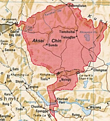
ラナク・ラ(英語: Lanak La, Lanak Pass、中国語: 拉那克山口、ヒンディー語: लानक दर्राは、カシミールにある峠である。インド・中国の国境係争地域で中国が実効支配しているアクサイチンの東の境界線上にあり、インドはこの峠を国境とみなしている。
歴史[編集]

ラナク・ラは、ラダックとチベットとの間の国境地帯にあり、1820年のウィリアム・ムーアクロフトら、この地方を訪れた旅行者もそれを確認している[2]。19世紀後半と20世紀初頭に訪れた何人かの旅行者は、インドとチベットの間の伝統的な国境はラナク・ラにあり、それは双方の国に受け入れられていたと述べている[3][4][5][6][7][8][9][10]。
ラナク・ラまでのチャンチェンモ渓谷地域については、カシミール政府の記録が大量に残っている。歳入記録、1908年のラダック入植報告書、いくつかの調査団の報告書、1951年のジャンムー・カシミール狩猟保護法のほか、チャンチェンモ渓谷の貿易ルート、休憩所、倉庫の建設と維持に関するカシミールの文書がある。これらの文書では全て、ラナク・ラまでの渓谷地域全体をラダックの一部と位置づけていた[11]。
中国の主張[編集]

中国の地図でも、1951年まではラナク・ラを国境としていた[12]。1956年、中華人民共和国は初の自国領土を規定する地図を発表し、その中ではラナク・ラの西のコンカ・ラが国境線として記されていた。
1956年まで、ラナク・ラにはインドの旗が立てられていた[13][14]。1958年6月にインドの警備隊がチャンチェンモ渓谷に沿って峠を上ったときには、ラナク・ラの地域に中国の存在の兆候は見られなかった[15]。
翌1959年には中国軍がチャンチェンモ渓谷に潜入していた。1959年10月、インド国境警備隊がコンカ・ラ付近に駐屯地を設けようとしていたところ[16]、中国軍の待ち伏せを受けて銃撃戦となり、何人かのインド兵が死亡し、一部が捕虜にされた(コンカ・ラ事件)[16]。
ラリー・ウォーツェルやアレン・S・ホワイティングなど、西洋の一部の学者は、コンカ・ラがチベットの伝統的な境界線であるという中国の主張を支持している[17][18]。しかし、他の多くの学者は、中国の主張の矛盾を指摘している[19][20]。
歴史的な地図[編集]
-
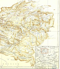 セシル・ローリング作の1905年の地図。右下の広域図では、ラナク・ラに国境線が引かれている。
 -
 ラナク・ラを含む地図(1917年)
 -
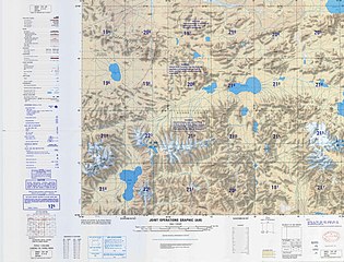 ラナク・ラを含む地図(1989年、アメリカ国防地図局(DMA))
 -
 ラナク・ラを含む地図("La-na-k'o Shan-k'ou"と書かれている)
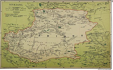
_(14776461552).jpg)
_p61_PLATE19._SINKIANG_(14597194848).jpg)


脚注[編集]
- ^ Drew, Frederic (1875), The Jummoo and Kashmir Territories: A Geographical Account, E. Stanford
- ^ Richardson, H. E. (1962). A Short History of Tibet. E. P. Dutton. p. 225
- ^ Wellby, M.S. (1898). Through Unknown Tibet. Lippincott. p. 78. ISBN 9788120610583
- ^ Carey, A. D. (1887). “A Journey round Chinese Turkistan and along the Northern frontier of Tibet”. Proceedings of the Royal Geographic Society 9 (12): 731–752. doi:10.2307/1801130. JSTOR 1801130.
- ^ Bower, Hamilton, Diary of A Journey across Tibet, London, 1894
- ^ Rawling, C. G., The Great Plateau Being An Account Of Exploration In Central Tibet, 1903, And Of The Gartok Expedition 1904-1905, p 38, London, 1905
- ^ Deasy, H. H. P. (Aug 1900). “Journeys in Central Asia”. The Geographical Journal 6 (2): 142. JSTOR 1774554.
- ^ Bruce, C. D. (Jun 1907). “A Journey across Asia from Leh to Peking”. The Geographical Journal 29 (6): 600. doi:10.2307/1776269. JSTOR 1776269.
- ^ “Report of the Officials of the Governments of India and the People's Republic of China on the Boundary Question - Part 2”. Ministry of External Affairs, India, 1961. 2013年9月21日時点のオリジナルよりアーカイブ。2020年11月6日閲覧。
- ^ Verma, Virendra Sahai (2006). “Sino-Indian Border Dispute At Aksai Chin - A Middle Path For Resolution”. Journal of Development Alternatives and Area Studies 25 (3): 6–8. ISSN 1651-9728 2013年8月30日閲覧。.
- ^ Fisher, Margaret W.; Rose, Leo E.; Huttenback, Robert A. (1963). Himalayan Battleground: Sino-Indian Rivalry in Ladakh. Praeger. p. 112
- ^ Karackattu, Joe Thomas (2020). “The Corrosive Compromise of the Sino-Indian Border Management Framework: From Doklam to Galwan”. Asian Affairs 51 (3): 590–604. doi:10.1080/03068374.2020.1804726.
- ^ Hudson, Geoffrey Francis (1963). Far Eastern Affairs, Volume 3. St. Martin's Press. p. 20
- ^ “Notes, Memoranda and letters Exchanged and Agreements signed between The Governments of India and China - White Paper VIII”. 2013年9月21日時点のオリジナルよりアーカイブ。2020年11月6日閲覧。
- ^ Mullik, B. N. (1971), My Years with Nehru: The Chinese Betrayal, Allied Publishers
- ^ a b Maxwell, Neville (1970). India's China War. New York: Pantheon. p. 13
- ^ Wortzel, Larry (2003). Burkitt, Laurie; Scobell, Andrew; Wortzel, Larry. eds. The Lessons of History: The Chinese People's Liberation Army at 75. Strategic Studies Institute, U.S. Army War College. p. 331. ISBN 9781428916517. オリジナルの2005-11-13時点におけるアーカイブ。 2020年11月6日閲覧。
- ^ Whiting, Allen S. (1987). “The Sino-Soviet Split”. In MacFarquhar, Roderick; Fairbank, John K.. The Cambridge History of China, Volume 14. Cambridge University Press. p. 512. ISBN 978-0-521-24336-0
- ^ Fisher, Rose & Huttenback, Himalayan Battleground (1963), p. 101: "Confusion as to the extent of the Chang Chenmo valley between the Lanak and Kongka passes continued to be a feature of Chinese cartography even after the Communists came to power.... the flexibility shown by official Chinese cartographers here and on other sections of the border makes mockery of China's oft-repeated claim that its concept of the border has a solid basis in history."
- ^ Van Eekelen, Willem Frederik (1967), Indian Foreign Policy and the Border Dispute with China, Springer, ISBN 978-94-017-6555-8, ""The Chinese could not quote a single document confirming that the Kongka Pass constituted the boundary.... The thorough approach of the Indian side generally contrasted with an inconsistent and almost careless presentation by the Chinese officials.""
参考文献[編集]
- Fisher, Margaret W.; Rose, Leo E.; Huttenback, Robert A. (1963), Himalayan Battleground: Sino-Indian Rivalry in Ladakh, Praeger